|
Chapter 10 (part D)
I take this opportunity of giving a
translation of the answer I made to an article published by M. G.
Nikolaïdes (p.176) in No. 181 of the Greek newspaper ‘?f?µe???
S???t?se??,’ in which the author endeavours to prove that I am giving
myself unnecessary trouble, and that the site of Troy is not to be
found here, but on the heights of Bunarbashi. [174]
“M.
Nikolaïdes maintains that the site of Troy cannot be discovered by
means of excavations or other proofs, but solely from the Iliad. He is
right, if he supposes that Ilium is only a picture of Homer’s
imagination, as the City of the Birds was but a fancy of Aristophanes.
If, however, he believes that a Troy actually existed, then his
assertion appears most strange. He thereupon says that Troy was
situated on the heights of Bunarbashi, for that at the foot of them are
the two springs beside which Hector was killed. This is, however, a
great mistake, for the number of springs there is forty, and not two,
which is sufficiently clear from the Turkish name of the district of
the springs, ‘Kirkgiös’ (40 eyes or springs). My excavations in 1868,
on the heights of Bunarbashi, which I everywhere opened down to the
primary soil, also suffice to prove that no village, much less a town,
has ever stood there. This is further shown by the shape of the rocks,
sometimes pointed, sometimes steep, and in all cases very irregular. At
the end of the heights, at a distance of 11œ miles from the Hellespont,
there are, it is true, the ruins of a small town, but its area is so
very insignificant, that it cannot possibly have possessed more than
2000 inhabitants, whereas, according to the indications of the Iliad,
the Homeric Ilium must have had over 50,000. In addition to this, the
small town is four hours distant, and the 40 springs are 3œ hours
distant, from the Hellespont; and such distances entirely contradict
the statements of the Iliad, according to which the Greeks forced their
way fighting, four times in (p.177) one day, across the land which lay
between the naval camp and the walls of Troy.
“M. Nikolaïdes’s
map of the Plain of Troy may give rise to errors; for he applies the
name of Simoïs to the river which flows through the south-eastern
portion of the Plain, whereas this river is the Thymbrius, as Mr. Frank
Calvert has proved. In his excavations on the banks of that river, Mr.
Calvert found the ruins of the temple of the Thymbrian Apollo, about
which there cannot be the slightest doubt, owing to the long
inscription which contains the inventory of the temple. Then on the map
of M. Nikolaïdes I find no indication whatever of the much larger river
Doumbrek-Su, which flows through the north-eastern portion of the Plain
of Troy, and passed close by the ancient town of Ophrynium, near which
was Hector’s tomb and a grove dedicated to him.[175] Throughout all
antiquity, this river was called the Simoïs, as is also proved by
Virgil (Æn. III. 302, 305). The map of M. Nikolaïdes equally ignores
the river which flows from south to north through the Plain, the
Kalifatli-Asmak, with its enormously broad bed, which must certainly at
one time have been occupied by the Scamander, and into which the Simoïs
still flows to the north of Ilium. The Scamander has altered its course
several times, as is proved by the three large river-beds between it
and the bed of the Kalifatli-Asmak. But even these three ancient
river-beds are not given in the map of M. Nikolaïdes.
“In
complete opposition to all the traditions of antiquity, the map
recognises the tomb of Achilles in the conical sepulchral mound of
In-Tépé, which stands on a hill at the foot of the promontory of
Rhœteum, and which, from time immemorial, has been regarded as the tomb
of Ajax. During an excavation of this hill, in 1788, an (p.178) arched
passage was found, about 3Ÿ feet high, and built of bricks; as well as
the ruins of a small temple. According to Strabo (XIII. 1. p. 103), the
temple contained the statue of Ajax, which Mark Antony took away and
presented to Cleopatra. Augustus gave it back to the inhabitants of the
town of Rhœteum, which was situated near the tomb. According to
Philostratus (Heroica, I.), the temple, which stood over the grave, was
repaired by the Emperor Hadrian, and according to Pliny (H. N., V. 33),
the town of Aianteum was at one time situated close to the tomb. On the
other hand, throughout antiquity, the tomb of Achilles was believed to
be the sepulchral mound on an elevation at the foot of the promontory
of Sigeum, close to the Hellespont, and its position corresponds
perfectly with Homer’s description.[176]
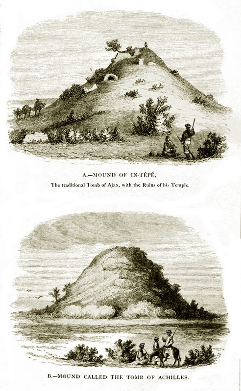
Plate VI: A (top): Mound of In-Tepe, The traditional Tomb of Ajax, with the Ruins of his Temple.
B (bottom): Mound called the Tomb of Achilles. (p.178)
“The
field situated directly south of this tomb, and which is covered with
fragments of pottery, is doubtless the site of the ancient town of
Achilleum, which, according to Strabo (XIII. 1. p. 110), was built by
the Mitylenæans, who were for many years at war with the Athenians,
while the latter held Sigeum, and which was destroyed simultaneously
with Sigeum by the people of Ilium. Pliny (H. N., V. 33) confirms the
disappearance of Achilleum. The Ilians here brought offerings to the
dead, not only on the tomb of Achilles, but also upon the neighbouring
tombs of Patroclus and Antilochus.[177] Alexander the Great offered
sacrifices{179} here in the temple of Achilles.[178] Caracalla also,
accompanied by his army, offered sacrifices to the manes of Achilles,
and held games around the tomb.[179] Homer never says anything about a
river in the Greek camp, which probably extended along the whole shore
between Cape Sigeum and the Scamander, which at that time occupied the
ancient bed of the Kalifatli-Asmak. But the latter, below the village
of Kumköi, is at all events identical with the large bed of the small
stream In-tépé-Asmak, which flows into the Hellespont near Cape Rhœteum.
“M. Nikolaïdes further quotes the following lines from the Iliad (II. 811-815):—
?st? d? t?? p??p?????e p????? a?pe?a ??????,
?? ped?? ?p??e??e, pe??d??µ?? ???a ?a? ???a,
??? ?t?? ??d?e? ?at?e?a? ?????s???s??,
????at?? d? te s?µa p???s????µ??? ???????.
???a t?te ????? te d??????e? ?d’ ?p???????.
‘Before the city stands a lofty mound,
Each way encircled by the open plain;
Men call it Batiea; but the Gods
The tomb of swift Myrina; mustered there
The Trojans and Allies their troops arrayed.’
M.
Nikolaïdes gathers from this, that in front of Ilium there was a very
high hill, upon which the Trojan army of 50,000 men were marshalled in
battle-array. I, however, do not interpret the above lines by supposing
that the mound of Batiea was large and spacious, nor that 50,000 were
marshalled upon it in battle-array. On the contrary, when Homer uses
the word ‘a?p??’ for height, he always means ‘steep and lofty,’ and
upon a steep and lofty height 50,000 Trojans could not possibly have
been marshalled. Moreover, the poet expressly says that the steep hill
is called by the gods the tomb of the nimble-limbed Myrina,{180} while
‘Batiea,’ the name which men gave the hill, can signify only ‘the tomb
of Batiea.’ For, according to Apollodorus (iii. 12), Batiea was the
daughter of the Trojan King Teucer, and married Dardanus, who had
immigrated from Samothrace, and who eventually became the founder of
Troy.[180] Myrina was one of the Amazons who had undertaken the
campaign against Troy.[181] Homer can never have wished us to believe
that 50,000 warriors were marshalled upon a steep and lofty tumulus,
upon whose summit scarcely ten men could stand; he only wished to
indicate the locality where the Trojan army was assembled; they were
therefore marshalled round or beside the tumulus.
“M. Nikolaïdes
goes on to say, that such a hill still exists in front of Bunarbashi,
whereas there is no hill whatever, not even a mound, before Ilium
Novum. My answer to this is that in front of the heights of Bunarbashi
there are none of those conical tumuli called ‘s?µata’ by Homer, that
however there must have been one in front of Hissarlik, where I am
digging, but it has disappeared, as do all earthen mounds when they are
brought under the plough.[182] Thus, for instance, M. Nikolaïdes,
during his one day’s residence in the Plain of Troy in the year 1867,
still found the tumulus of Antilochus near the Scamander, for he speaks
of it in his work published in the same year. I, too, saw the same
tumulus in August, 1868, but even then it had considerably decreased in
size, for it had just begun to be ploughed over, and now it has long
since disappeared.
“M. Nikolaïdes says that I am excavating in
New Ilium. My answer is that the city, whose depths I am investigating,
was throughout antiquity, nay from the time of its foundation to that
of its destruction, always simply called Ilium, and that no one ever
called it New Ilium, for everyone (p.181) believed that the city stood on
the site of the Homeric Ilium, and that it was identical with it. The
only person who ever doubted its identity with Ilium, the city of
Priam, was Demetrius of Scepsis, who maintained that the famous old
city had stood on the site of the village of the Ilians (?????? ??µ?),
which lies 30 stadia (3 geog. miles) to the south-east. This opinion
was afterwards shared by Strabo, who however, as he himself admits, had
never visited the Plain of Troy; hence he too calls the town ‘t?
s?µe????? ?????,’ to distinguish it from the Homeric Ilium. My last
year’s excavations on the site of the ?????? ??µ? have, however, proved
that the continuous elevation on one side of it, which appeared to
contain the ruins of great town walls, contains in reality nothing but
mere earth. Wherever I investigated the site of the ancient village, I
always found the primary soil at a very inconsiderable depth, and
nowhere the slightest trace of a town ever having stood there. Hence
Demetrius of Scepsis and Strabo, who adopted his theory, were greatly
mistaken. The town of Ilium was only named Ilium Novum about 1000 years
after its complete destruction; in fact this name was only given to it
in the year 1788 by Lechevalier, the author of the theory that the
Homeric Ilium stood on the heights of Bunarbashi. Unfortunately,
however, as his work and map of the Plain of Troy prove, Lechevalier
only knew of the town from hearsay; he had never taken the trouble to
come here himself, and hence he has committed the exceedingly ludicrous
mistake, in his map, of placing his New Ilium 4Πmiles from Hissarlik,
on the other side of the Scamander, near Kum-kaleh.
“I wonder
where M. Nikolaïdes obtained the information that the city which he
calls Ilium Novum was founded by Astypalæus in the sixth century B.C.
It seems that he simply read in Strabo (XIII. 602), that the
Astypalæans, living in Rhœteum, built on the Simoïs the town of Polion
(which name passed over into Polisma), which, as (p.182) it had no natural
fortifications, was soon destroyed, and that he has changed this
statement of Strabo’s by making the Astypalæans build Ilium Novum in
the sixth century B.C. In the following sentence Strabo says that the
town (Ilium) arose under the dominion of the Lydians, which began in
797 B.C. Whence can M. Nikolaïdes have obtained the information that
the foundation of the town was made in the sixth century?
“M.
Nikolaïdes further says that Homer certainly saw the successors of
Æneas ruling in Troy, else he could not have put the prophecy of that
dynasty into the mouth of Poseidon.[183] I also entertained the same
opinion, until my excavations proved it to be erroneous, and showed
undoubtedly that Troy was completely destroyed, and rebuilt by another
people.
“As a further proof that the site of the Homeric Ilium
was on the heights of Bunarbashi, M. Nikolaïdes says that the Trojans
placed a scout on the tumulus of Æsyetes, to watch when the Achæans
would march forth from their ships, and he thinks that, on account of
the short distance from the Hellespont, this watching would have been
superfluous and unreasonable if, as I say, Troy had stood on the site
of Ilium, which M. Nikolaïdes calls Ilium Novum. I am astonished at
this remark of M. Nikolaïdes, for, as he can see from his own map of
the Plain of Troy, the distance from hence to the Hellespont is nearly
four miles, or 1œ hour’s walk, whereas no human eye can recognise men
at a distance of 1 mile, much less at a distance of four. M.
Nikolaïdes, however, believes the tumulus of Æsyetes to be the mound
called Udjek-Tépé, which is 8 miles or 3œ hours’ journey from the
Hellespont. But at such a distance the human eye could scarcely see the
largest ships, and could in no case recognise men. (p.183)
“In like
manner, the assertion of M. Nikolaïdes, that there is no spring
whatever near Hissarlik, is utterly wrong. It would be unfortunate for
me if this were true, for I have constantly to provide my 130 workmen
with fresh water to drink; but, thank God, close to my excavations,
immediately below the ruins of the town-wall, there are two beautiful
springs, one of which is even a double one. M. Nikolaïdes is also wrong
in his assertion that the Scamander does not flow, and never has
flowed, between Hissarlik and the Hellespont; for, as already stated,
the Scamander must at one time have occupied the large and splendid bed
of the Kalifatli-Asmak, which runs into the Hellespont near Cape
Rhœteum, and which is not given in the map of M. Nikolaïdes.
“Lastly,
he is completely wrong in his statement that the hill of Hissarlik,
where I am digging, lies at the extreme north-eastern end of the Plain
of Troy; for, as everyone may see by a glance at the map, the Plain
extends still further to the north-east an hour and a half in length
and half an hour in breadth, and only ends at the foot of the heights
of Renkoï and the ancient city of Ophrynium.
“It will be easily
understood that, being engaged with my superhuman works, I have not a
moment to spare, and therefore I cannot waste my precious time with
idle talk. I beg M. Nikolaïdes to come to Troy, and to convince himself
with his own eyes that, in refuting his erroneous statements, I have
described all I see here before me with the most perfect truth." (p.184)
Footnotes:
[174]
We do not feel it right to spoil the unity of the following
disquisition by striking out the few repetitions of arguments urged in
other parts of the work.—[Ed.]
[175] Strabo, XIII. i. p. 103; Lycophron, Cassandra, 1208. See further, on the Simoïs, Note A, p. 358.
[176] Odyssey, XXIV. 80-81:
Ἀμφ’ αὐτοῖσι δ’ ἔπειτα μέγαν καὶ ἀμύμονα τύμβον
Χεύαμεν Ἀργείων ἱερὸς στρατὸς αἰχμητάων,
Ἀκτῇ ἐπὶ προυχούσῃ, ἐπὶ πλατεῖ Ἑλλησπόντῳ,
Ὥς κεν τηλεφανὴς ἐκ ποντόφιν ἀνδράσιν εἴη
Τοῖς, οἳ νῦν γεγάασι, καὶ οἳ μετόπισθεν ἔσονται.
“We
the holy army of the spear-throwing Argives, then raised round these
(bones) a great and honourable tomb on the projecting shore of the
broad Hellespont, so that it might be seen from the sea by the men who
are now born and who shall be hereafter.”—Dr. Schliemann’s translation.
[177] Strabo, XIII. 1.
[178] Plutarch, ‘Life of Alexander the Great'; Cicero, pro Archia, 10; Ælian, V. H., 12, 7.
[179] Dio Cassius, LXXVII.
[180] Iliad, XX. 215-218.
[181] Herodotus, I. 27; Iliad, III. 189-190; Strabo, XIII. 3.
[182] But see further on this point, Chapter XI., pp. 197-8.—[Ed.]
[183] Iliad, XX. 307-308, quoted in the Introduction, p. 19.
[Continue to Chapter 11]
|
|