|
Monuments from Egypt and Ethiopia, by Richard Lepsius. Volume I, Lower Egypt and Memphis.
(Original publication of plates 1849-1859; Explanatory text from
the 1897 German edition, edited by Kurt Sethe and Edouard Naville).
[Part 4]
Giza: 10 Nov 1842-10 February 1843 (p.24)
Site
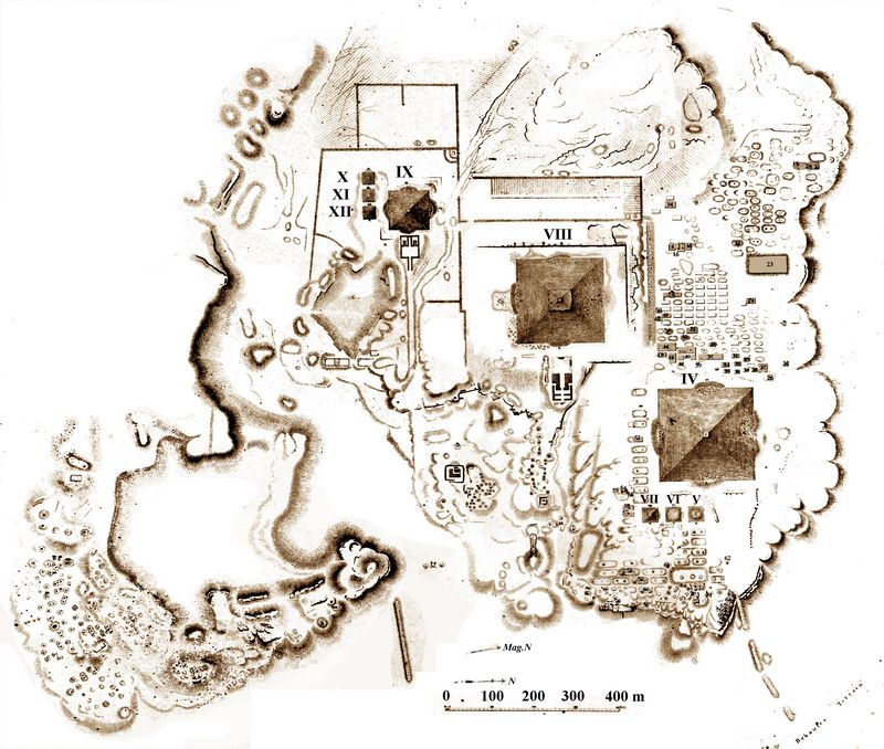
plan of the pyramid field: LD I 14 (fig.25), (to which the Arabic numbers of the
pyramids and graves refer below.) - Panorama of the 2nd pyramid: LD I
15-18. View of the pyramids from the south: LD I 19. Stone dam and rock
tomb in front of the largest pyramid: LF I 20. Grave field west of the
same pyramid, seen from the east: supplementary volume, plate II.
In
Giza we have three large pyramids, which belong to kings of the 4th
dynasty and are not only the most impressive, but also the best built.
- They lie on a large plateau that slopes to the N.E. and E. towards
the Nile valley, to the S. and S.W. but is enclosed by two thalers,
which unite to the west and continue in their formations to the Fayum.

The
entire plateau was obviously (p.25) demolished in its entirety for the
purpose of building the pyramids, and to the N.W. Thale has a wide
terrace, the entire length of which has also been demolished in order
to extract stone. This treatment gave the entire area a color tone very
different from the surrounding desert, which first drew my attention to
this type of quarry, which was previously unknown to me and others.
The
common practice was to detach the building blocks from the surface by
digging into the bedrock and then blasting off the separate blocks from
below. Often, however, people deliberately went into the depths in
terraces to excavate rock faces, which could then be hollowed out from
the side to form private graves. -- This method of processing can best
be seen in the pyramids of Zoawijet el Arrian, where the entire
mountain slope extending to the south is worked in this way over a
certain width; the grooves between the blockers to be released are
still visible, from c. 2 1/2 inches wide, and now give the entire edge
the appearance of a built wall or a large pavement broken down towards
the valley (see below). The same adaptation is, perhaps from a much
later (Ramesses) time, on the N.W. This is visible in the corner of the second pyramid (see
fig.25, the site plan Ld I 14; below p.32).
The color of
the desert hills is brown-yellow and the hard sand is covered with
countless, rounded, jasper-like stones; Only rarely do large,
snow-white veins in limestone rocks come to light, as is the case north
of the pyramid [No. II] from Abu Roasch and northwest of our pyramid
field. The grain of these rocks is very exposed to the weather, but is
very hard and hardly seems to have been used for building stones at
all. Where this rock is not exposed, the whitish color of the surfaces
is always an unmistakable sign of being worked and of the proximity of
old burial buildings or rock tombs.
The general remark is soon
made that the kings of the same dynasty were always buried in one area
and that the most respected people of his family, relatives, court and
time used to build their graves around the grave of a king. - By
building a pyramid, large areas of rock have always been obtained, the
stones of which were carved and used and which were now particularly
suitable for the construction of private graves. So each of the three
(p.26) great pyramids of Giza has a burial ground around it, which
adjoins it and whose layout is based on it.
1-9. The pyramids no. III-XII.
It
is difficult to see how the three great pyramids are built inside. The
8 or so steps that I once clearly perceived on the surface of the 2nd
pyramid on the N. side may perhaps also correspond to steps inside, as
described by Herodotus.
In addition to the 3 large pyramids,
there are also 6 small pyramids at Giza, three in front of the largest
and three in front of the third pyramid. They cannot have belonged to
kings, because they are obviously built after the great ones, to whom
they subordinate themselves due to their position, which no independent
king would have done. They must have been relatives of the kings buried
in the great places. (cf. Diodorus I, 64).
Some of these small
pyramids (see below) appear to have been built in steps, but the steps
were filled, as can clearly be seen, for example, in the southernmost
of the three small pyramids in front of the largest pyramid (No. VII).

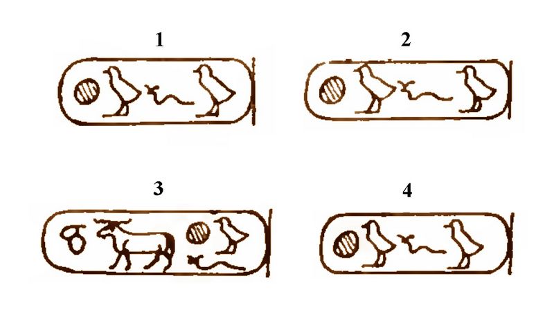
Fig.26: Fourth Dynasty name
cartouches from Pyramid IV (the Great Pyramid) at Giza, containing the
name of the 4th Dynasty pharaoh buried there [i.e., Cheops].
1.
Stone pyramid No. IV of (name cartouche; fig.26-1) [1], the
northernmost and largest of the three great pyramids of Giza. It is the
oldest of the three and belonged to (fig.26-2) or
(fig.26-3), whose name is known to be found written on the faces
of the pyramid: LD II 1 a-e (fig.27). The name (fig.26-4) appears on the
top blocks, but there is probably little significance to this.Fig.27: Fourth Dynasty Inscriptions on building stones at the Great Pyramid of Giza.(DM II, plate 1 a-e)
A stone sample from the so-called Chamber of Kings is now in Berlin No.1296.
The
pyramid has been pushed very close to the slope and the field has been
significantly blocked by rubble to the N. and E. It was nowhere near as
impressive and regular as the second pyramid.
In two pieces of
the black stone that was paved in front of the largest pyramid that I
took with me (one now in Berlin No. 1337), you can see the sharp corner
of two worked sides and the break. On one worked side you can see
traces of surface wear caused by large loads that appear to have been
rolled over it.
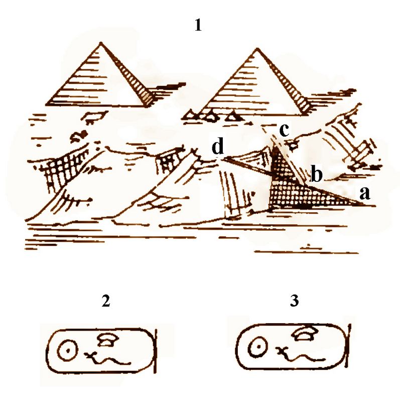
The pyramid is accessed from the N.E. From the
plane a large stone formation, which initially (p.27) runs in the
direction of the second pyramid, then bends at point b and heads
towards the large pyramid (fig.28-1). It is probable that
the Mokattem stones were carried along a canal from the Nile to point a
on the plain while the water was high, and then carried on rollers and
other machines at an angle (at b) to the height of c to avoid the too
steep rise to avoid which in no other direction [e.g. b, d ] could
easily be avoided; because this is the rocky peak that projects
furthest into the valley.

Fig.28: 1) plan of access ramp of Pyramid IV, labelled a-d as in text..
2) cartouche of Pyramid VIII (Chephren). 3) name cartouche from private grave near Chephren's puyramid.
A piece of its covering stone is still
preserved, it is made of solid, good quality Mokattem stone. The
surface has obviously been hardened and polished, perhaps it was even
painted red, if the remains of the red paint in the front joints, which
can be clearly observed, have no other origin. Samples of the covering
are now in Berlin No. 1335, 1339, 1341; the same sample of morter No.
1334, 1342. - It is only apparent; that the second pyramid was built
more poorly and irregularly than the first; The covering has just
broken off more irregularly and appears to have sat tighter.

Fig.29: a-c: Sketch of position and anchoring of stones in pyramid VIII at Giza.
The
top stratum now has 3.88 m, the next [layer] has 4.20, the third 5.18.-
Almost all the stones have been pushed out of their (p.28) layers to
some extent.-
The top step is 0.54 [m high].
The
second pyramid runs in the middle of the rock plateau and on the
highest point of it, which is why it significantly towers over the
actually higher, largest pyramid in terms of absolute height (above sea
level). It stands on a curve that diverts the water flows to both sides
and is surrounded on all sides by large, regular walls.
The rock
formed a wide terrace towards the valley side, which from the front
must have appeared like a broad base. The entire terrace (in front of
the pyramid), which like the entire plateau sloped down from the back,
was built into a regular, flat surface with enormous blocks that can
hardly be distinguished from the natural rock. In the middle, this
natural, flattened rock terrace jutted out far enough to support a
stately temple.
What is striking is that the 2nd pyramid no
longer shows an increased height like the largest and third. One could
assume that the path to the temple originally led up the valley that
was straight down to it, since this was not the natural rocky slope,
but rather cut through the rocks. The rock wall, which now runs
diagonally up directly in front of the temple, originally had to go
through strong masonry which must have been filled out to form a
regular front wall.
But this is not likely; for all along the
valley there are graves of Psammetich; However, the complete collapse
of the unusually large structure, which would have to be assumed, could
not be explained at such an early date; there is no trace of it left.
Furthermore, the hollowing out of the usual elevation would be
inexpedient; Finally, the path at the end of the valley would be too
narrow and the rock of the uninhabited graves would extend too far
ahead.
3. Stone Pyramid No. IX of the (name cartouche; fig.30-1) [3], the southernmost of the three great pyramids (p.29). It
belonged to the (name cartouche, fig.30-2) [as evidenced by the inscription on
the sarcophagus lid found in it, now kept in the British Museum in
London, LD II 2e; fig.30-3].
The lower half of the pyramid was covered in
granite. - In front of the Pyramid there is a temple from which a stone
path leads to the plain.
The third pyramid lies on the slope of
the rock to the N. From it and from the second pyramid it can be
clearly seen that the entire large plan behind the pyramids has been
demolished and smoothed by people. From here come the stones to the two
large pyramids, which must have been taken from close up (see above
p.24/5) - The large depression in front of the third pyramid seems to
have supplied the stones to it; the rocks are sharply cut and appear to
contain graves.
Fig.30: 1, 2: Name cartouches of Pyramid IX.
3) Inscription containing the same name cartouche on a wooden sarcophagus in the British Museum (DM II, plate 2e).
4-6. Stone pyramids No. V-VII [4],
the three small ones on the east side of the largest pyramid. All 3 of
them were built in stages.
7-9. Stone pyramids No. X-XII [5], the three small ones on the south side of the
third large pyramid. The easternmost one (No. XII) was partially
destroyed by the French expedition (see Jomard, Descr. Tom V Chap. XVIII, #IV, p. 656).
Footnotes:
1. Perring No.2.
2. Perring No.6.
3. Perring No.7.
4. Perring No. 3-5.
5. Perring No. 10, 9, 8.
[Continue to next part]
[Return to Table of Contents]
|
v |