Athena Review Image Archive ™
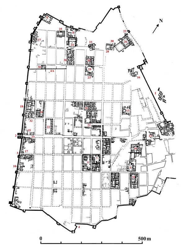
Dura-Europos: Plan of the Roman and Parthian site

Plan of Dura-Europos, with Roman and Parthian features labelled (after Rostovtzeff 1938)
This plan by Rostovtzeff (1938) shows excavated features from the Roman and Parthian periods of Dura-Europos, located on the Euphrates River near the modern town of as Salhiyah. The site was excavated in the 1920s and 30s in a Yale University project directed by Rostovtzeff. Areas labelled with red numbers are identified as follows:
Fortifications: 1. Citadel and its palace. 2. Main gate. 3. Subsidiary gate on the desert front. 4. South gate. 4A. Brick wall of the Roman Military Camp.
Temples: 5. Artemis-Nanaia. 6. Zeus Megistos. 7. Atargatis. 8. Azzanathcona. 9. Bel (?) NW corner. 10. Zeus Kyrios. 11. Aphlad. 12. Gadde. 13. Zeus Theos. 14. Adonis. 15. Tyche. 16. Military chapel. 17. Christian Church. 18. Synagogue.
Public Buildings: 19. Acropolis Strategion. 20. Agora. 21. Sukhs. 22. Khan. 23. Baths.
Military Buildings: 24. Praetorium. 25. House of a Higher Officer. 26. Palace of the dux. 27. Mithraeum. 28. Dolicheneum. 29. Amphitheater. 30. Barracks,
Private Houses: 31. House of Lysias. 32. House of the Scribes.
Note: The excavated buildings are shown in plan with solid lines. Excavated streets are shown with solid outlines, while unexcavated streets are shown with dotted lines.
.Copyright © 1996-2020 Rust Family Foundation (All Rights Reserved).