|
Chapter 2 (part 2)
4. Layer II, the prehistoric Trojan Castle.
In
contrast to the Layer I settlement, the buildings of which are only
partially uncovered and therefore only a little known, the IInd layer
has almost exclusively been excavated and examined by Schliemann. It
was at first considered the castle of the Homeric age and therefore
primarily formed the subject of his work and research. What was
preserved from their enclosure systems and its inner buildings during
the excavation has already been specified in the previous publications
and mostly discussed in detail. Part of the castle wall and the
southwest tower have experienced a description in the book Ilios (p. 42 ff. and 345 ff.). Then several buildings of layer II were treated in the book Troy (1882, pp. 59-99) due to my information from Schliemann. In the Reports
about the excavations of 1890, I myself discussed the preserved
buildings on pages 41-57. Some supplements are given in the book Troy 1893 (pp. 61-64).
Although
only a few new buildings have been added due to the excavations of 1894
and therefore our knowledge of the layer has only been expanded, a
detailed discussion of all of their buildings in this summary book
still seems to me to have all the more justification because the older
descriptions contain several errors and contradictions. In addition,
the ancient buildings from the third millennium can command our
full attention (p.50), especially since it is not just a few
incomprehensible walls, but also an entire castle complex with their
fortress walls, towers, magazines, and inner buildings.
The IInd layer is essentially identical to the "burned city", as Schliemann called and described it in his book Ilios.
Only he mistakenly counted the buildings of the IIIrd layer, those poor
huts that were only built over the destroyed buildings of the layer II
settlement. Now such a mistake is no longer possible, now the houses
and castle walls of layer II are layered easily from the older and
younger buildings as far as they are preserved.
Firstly, they
are almost exactly in one and the same height through all parts of the
hill, so that confusion with the higher or lower buildings is almost
excluded. Secondly, they have a peculiar design of them: their upper
walls consist of unbroken bricks and wood, their foundations and
substructures made of stones with earth mortar; In contrast, the upper
walls of quarry stones or cuboids also consist of the buildings of the
older and younger layers.
Thirdly, the structures of Layer
II can be recognized by the strong signs of fire that are visible
everywhere as witnesses of a huge conflagration. An almost 2m high
layer of yellow, red and black fire rubble covered all ruins that had
escaped the destruction. This rubble, which Schliemann referred to in
the book Ilios so often
and mistakenly as wood ash, consists in reality of burned (yellow),
half -burned (black) and very burned (red) clay brick residues, mixed
with soil, carbon, slag and other burned objects. It seems to have been
found everywhere, as far as the IInd layer is concerned; at the moment
it can only be seen on the standing cones in E 4, E 6 and F 4, as well
as near the castle wall remains
Schliemann's information about
the location of this fire layer and about the finds made in it may be
considered correct; at least we later found its details confirmed in
several places. He was only wrong by including the small stone houses
of layer III that were on the fire rubble to the "burned city". How he
came about this can be easily understood when looking at the
circumstances. When the settlers of the third stratum built their
apartments from small stones on the top of the rubble hill, they had to
have the foundations placed in the rubble to provide the walls. During
the excavation by Schliemann, various rubble masses were now found
between the tops of the walls, but between their lower parts was that
yellow, red and black burned rubble. Schliemann now calculated the
latter, as well as the numerous objects found therein, to belong to the
layer of the stone huts, and did not pay attention to the fact that the
rubble between the dividers of their walls could not be part of them,
but was absolutely older. (p.51)
In some places of the castle,
especially in the western parts, he had uncovered the correct walls of
the IInd layer, while in the eastern parts and in the middle the
remains of this layer were still buried under the younger ruins and the
rubble layer, and therefore have not yet been found. It was only
through the results of the excavations of 1882 that he was convinced of
his error, and now correlated in the book Troy
(1882, p. 59) the strong fire layer with its numerous finds properly to
the large brick buildings of layer II, and recognized in the higher
lying huts a poor village that was built on the rubble of the destroyed
town of layer II. I considered it my duty to explain this fact, which
has often given rise to misunderstandings and incorrect judgments.
The
Castle of the IInd layer is now exposed to almost its entire extent.
Only in the eastern parts of the hill some pieces below the younger
layers have remained unreachable. Even in the middle of the hill, small
parts of Megara II A and II B and the neighboring building are still
hidden in the untouched surrounding earth. Nevertheless, neither the
interior buildings nor the surrounding walls of the IInd layer castle
are fully known. Some of their buildings consisting of clay bricks had
already been completely destroyed in ancient times in the downfall of
the castle that their shape can no longer be recognized. Unfortunately,
others were destroyed by Schliemann in his first excavations without
being recognized as old brick walls.
Anyone who has ever dug
up walls from unbroken bricks will not blame the much-deserving
researcher from overlooking the brick walls, because he would
know from experience that special knowledge and great attention are
required in order to recognize such walls at all, and to distinguish
them from rubble masses around them. The places where the buildings of
the IInd layer have already been destroyed in antiquity, especially in
the northern parts of the castle, where the hill fell steeply and
caused a complete destruction of the walls. The buildings destroyed by
Schliemann were mainly located in the middle of the castle and mostly
went under in the production of the great north-south trench.
Fortunately, the floor plans of the destroyed buildings can be
supplemented with some certainty from the remnants still preserved.
As
a whole, the preservation of the buildings of the IInd layer is
sufficient to at least restore a large part of the castle wall with
their gates and also part of the inner courtyards with their buildings.
However, there is no uniform castle plan, rather you can see several
castle walls and several buildings. Already during (p.52) the
excavations of 1879 and 1882, it had been observed that there were
multiple conversions both the ring wall and the inner building. In
1890, three different periods were significantly differentiated. The
castle had experienced an expansion twice and at the same time an
almost completely conversion of the interior. In the plan of the report
on the excavations of 1890 (repeated in our photo 3 on p. 16), the
attempt was made to illustrate the development of the castle in the
course of the 3 periods.
Since these conversions took place
without significant increase in the inner floor of the castle, only the
foundations could be preserved from the buildings of the older periods.
In contrast, the preservation of the older systems, at least in the
south and east, was better seen in the castle wall and the gates,
because the conversion was associated with an expansion of the castle
circumference. The entire substructure of the older ring wall remained
here and was covered by the new wall built in front of it. While we can
easily distinguish and discuss the older period at the castle wall, the
knowledge of the older floor plans is very difficult for the interior
buildings, owing to the lack of all upper walls and even many
foundations. We therefore have to limit ourselves to the buildings of
the interior to describe the buildings of the latest period and to
mention the remains of the older buildings. At the castle wall,
however, we can discuss the individual walls in their historical order.
The
castle walls of all three periods are consistent in that they consist
of a substructure of limestone and earthen mortar, on which an upper
wall of mudbrick stood, and in part still stands. The lower wall is
more or less heavily sloped and extends to the inner floor of the
castle. It is a retaining wall with only one outward-facing facade. Its
stones, even those of the facade, are almost unworked.
The
inner boundary of the wall was always underground and only shows a
regular construction at the top. The core of the substructure is
assembled without care from completely unworked chunks of stone. Earth
is used to bind the stones, but there are also walls in which no mortar
seems to have been used at all. The strong embankment was due to the
small size of the stones and the poor quality of the masonry. At a
height of 1 m, it is between 1.00 and 0.50 m, so it is big enough that
you can climb up the wall without difficulty. You don't even have to
look for particularly large holes in the joints to insert your feet,
but can climb the protruding strips of the individual stone layers
almost like climbing a staircase.
It would be incorrect to
conclude from this that the wall could not have been a fortress wall;
on the contrary, due to the small size of the stones used, the strong
slope could not be avoided. The retaining wall would undoubtedly (p.53)
have yielded to earth pressure and fallen over if the outside had not
been sloped. Also, an unbanked wall could easily be brought down by the
attacking enemy by removing the lower stones. The inconvenience that
the wall could be climbed was completely eliminated by giving the wall
a superstructure made of mud bricks with a vertical outer side. If an
attacker had climbed up the sloping substructure, he was in a bad
position on the vertical brick wall: he could easily be thrown down by
the defenders standing on top of the wall, without being able to resist
himself.
Unsloped or slightly sloped fortress walls can only
be built of unworked stones if the individual stones are of such large
dimensions as the blocks of the Cyclopean walls of Tiryns or Mycenae.
Such huge stones were either not available to the builders of the II
Troy Castle or were considered superfluous. Photo 6 gives a good idea
of the substructure of the castle wall. You can see the western wall
from the gate EM to the western tower FH.
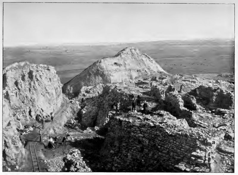
Photo 6: Southwestern castle wall of the IInd layer (a-c) and house walls of younger layers (d).
The
actual defensive wall was the brick upper wall. It had been placed on a
stone foundation so that it could not be reached by the earth's
moisture, nor easily undermined or destroyed by the attackers standing
on the ground floor. The height of this substructure depended on the
height of the slope on which the wall was to be erected, and varied
between 1.00 m and 8.50 m at the various points of the castle. On the
north side, where the wall has been completely destroyed, the height of
the substructure may have been even greater. The height of the brick
superstructure is unknown and, as far as I can see, cannot be
determined in any way. We only know that it was considerably higher
than 3m, because the eastern brick wall still reaches that level in
places, and yet large amounts of rubble lay before it. As the upper end
of the upper wall we may perhaps assume a gallery covered with wood and
a horizontal earthen covering; at least the strong burning of the upper
part of the wall indicates the presence of many wooden beams.
The
substructures of the three different Castle Walls II are best preserved
in squares C 6 and D 6, as can be seen on Plans III and IV, as well as
in the section on Plate VIII. The wall of the first period is the
innermost one and is shown to be the oldest wall, later no longer
visible, because it goes under the gate EM; so it was already destroyed
when this gate was built.
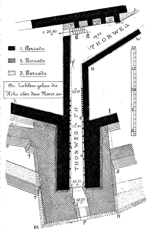
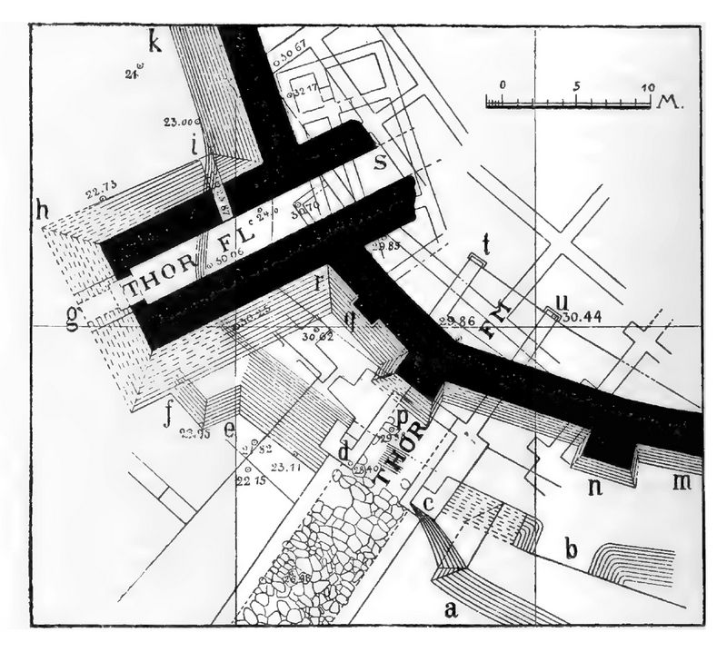 Fig.10 attempts to illustrate its
course in the south-western part of the castle. In this drawing it is
laid out entirely in black, while all other walls are left white. Now
about 2.70 m wide at its upper edge, it widens considerably downwards
be (p.54), the embankment is almost 1 m by 1 m in height. It is still
provided on its exterior with tower-like projections, two of which are
found at a distance of 10.6 m.
Fig.10: Gate FL and the adjoining castle wall in the first period of Layer II.
The eastern one (n in Figure 10) has a
width of about 3 m and projects 2 m in front of the wall line, the
other p seems to have the same dimensions. Both are located exactly
where the wall itself makes a bend, so they are attached to the corners
of the polygon formed by the ring wall.
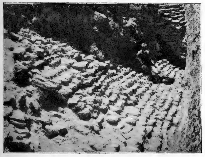
A photograph of the
tower n and the adjoining castle wall m is given in Photo 7. On the
left you can see the tower with its steep embankment, on the right the
substructure of the castle wall. Nothing remains of the brick
superstructure at this point, either on the tower or on the wall; it
was removed in ancient times when the younger wall was erected.
However, the fact that such a superstructure once existed everywhere is
confirmed by numerous remains of bricks that were found in the rubble
in front of the wall. (p.55) In another place (at r in fig.10) some bricks
are even preserved in their old position on the stone base.

Photo 7: Substructure of the southern castle wall (a-c) from the first period of Layer II.
The
course of the oldest wall of II cannot be traced around the entire
castle hill. On the west side it meets the younger castle walls and is
built over by them. At the north-west corner, in square C3, a piece of
wall has been found which, because of its steep slope, presumably
belongs to our wall range, if it does not have to be counted as part of
an even older circular wall.
Its appearance is illustrated in
fig.11, in which its steep slope is particularly visible. On the
northern slope of the hill, where the wall probably also collapsed with
the younger walls, it appears to have been destroyed in ancient times.
At the north-east corner, in squares G 3 and H 4, a heavily sloping
piece of wall is again preserved, which is drawn as a straight line on
panels III and IV according to the earlier plans, but in reality
appears to have a curvature. Due to the poor condition of the outside,
however, the size of the curvature could not be determined easily.
Since the section of wall is very similar in its (p.56) embankment and
the type of masonry to the wall uncovered in C 3, it must also have
belonged to the oldest wall section of Castle II.
 Not
only the brick upper wall but also the upper part of the lower wall is
destroyed here. Our assumption given in Plans III and IV that the
substructure here still supported the upper brick wall in the later
periods of Layer II must remain an unproven assumption. The terrain
conditions only ensure that the older and the younger wall must have
stood here in approximately the same place.
Fig.11: Castle wall in C3 on the north-west slope.
To
the east the course of our wall has been traced by a small piece
unearthed in 1894 at G5 south of IX R. It lies in the continuation of
the wall remains uncovered further south-west next to the gate FO. The
total perimeter of the ring wall, as we have determined it with some
certainty for the first period of the II layer, is about 300m. In the
later periods it grows only a little and and not until the sixth layer
does it almost double in extent.
According
to the well-preserved substructures of towers found in the
south-western part of the wall, one might assume that there were towers
protruding from our wall on all other sides of the castle. But whether
they really existed must remain undecided; only a few small remains of
walls in C3 and H4 may belong to such towers.
In at least two
places the wall was breached by gates indicated on Plans III and IV;
the smaller FL lies in B 5 and C 5, the larger FN in E6 and E 7.
Although of different dimensions, they show the same general shape. The
gateway is built over by a mighty tower that protrudes far in front of
the wall line and gradually rises within the tower. It does not reach
the plateau of the castle in the line of the castle wall, as is the
case with the younger gates, but only further inside the castle.
At
gate FN the path has been uncovered and examined almost in its entire
length. It has the low pitch ratio of 1:15, so it was good to use for
wagons. In the smaller gate FL we only know a short part of the way.
Uncovering it completely would only have been possible at the expense
of important younger buildings, and therefore had to be avoided. There
is no stone paving in either of the two gates, only a simple screed of
clay covered the floor. The width of the path is 3.50 m at the larger
gate and gradually decreases towards the inside, at the smaller one it
is about 2.60 m in the uncovered part.
 The floor plan of the
larger gate FN, which is repeated in fig.12 without the later
alterations according to Plans III and IV, is the best preserved. At
its front end, the gateway may have had a double closure (d and c, each
with two wooden gate wings, but the state of preservation of the walls
on the one hand and the later conversion to be mentioned (p.57) on the
other hand do not allow for a safe reconstruction. It is easy to
recognize only the lock c, which is 7.50 m from the end of the gate.
The complete burning of the projecting corners of the wall is due to
its major wood component. The traces of fire are still clearly visible here, 17
years after the excavation.
Fig.12: Floor plan of the FN gate in the 1st period of the 2nd layer.
If
we follow the ascending gateway towards the interior of the castle, we
first notice the standing marks of vertical wooden posts on the left
and right of the walls, which still enclose the path 2m high, which
once stood in front of the walls and are indicated in fig. 12 by two
rows of black dots.
They were apparently intended to support
the walls of the gateway, but also to support its ceiling and thus
presumably the floor of an upper storey. Set up at intervals of 1.30 -
2.10 m, according to their imprints in the plaster of the walls, they
must have been round, only slightly worked tree trunks. Their diameter
of about 0.20m is derived from the holes that were preserved in the
floor when they were found. At a distance of about 16m from the gate
lock the posts on the right side (at e) are placed much more densely,
and their small gaps are filled with rubble stone masonry. This is
probably due to the repair of a damaged piece of wall. Perhaps the side
wall had collapsed or was just about to collapse, and the presented
wooden wall lined with stones was then erected to gain greater strength.
(p.58)
In addition to the vertical timbers, horizontal wooden beams were also
installed in the side walls, the bearings of which are partly secured
by the corresponding cavities and partly by the remains of charcoal.
This large amount of wood and also the beams of the ceiling and the
superstructure provided the material for the great fire that destroyed
the gate building, and of whose magnitude the burnt masses of rubble
that filled the entire gate gave eloquent testimony. Even now it can
still be seen that the stones of the walls were burned in several
places by the fire which turned the lime and the clay used as mortar
and wall plaster into terracotta.
If we follow the gateway
further north beyond the Propylaion II C, which was later built over
it, we find in place of the vertical side walls on the left side an
embanked retaining wall and on the right a bend in the path and also
retaining walls on both sides. In any case, the change in the shape of
the side walls is related to the type of superstructure. As far as the
gateway was built over by a tower, it had vertical side walls supported
by wooden posts, as far as it was in the open air without a
superstructure, the wood was missing and the walls were laid out with
an embankment.
The transition from one type of construction to
the other was probably at f, i.e. opposite the point u, where the
right-hand side wall bends to the right. If the main path had climbed
in the same direction and with the same gentle incline to the height of
the second castle, it would have reached the plateau 4.50 m above the
entrance only beyond the center of the castle and thus cut through the
inner castle area in an unpleasant way. In order to avoid this, the
gateway, which could be used by carriages, was turned to the right (to
the north-east) and a stair-like ramp (g) was built for pedestrians, on
which the central square of the castle could be reached in a few steps.
After
the excavations of 1882, we had assumed that the gateway FN had been
built over with a tower about 18 m wide from the beginning. More recent
research, however, has confirmed the fact, first noticed in 1890, that
this large measure of latitude arose only in a more recent period
through the strengthening of the gate walls. As careful excavations
have shown, these side walls were originally only 3.50 - 4.00 m thick
and were later (probably in the 2nd period of the 2nd layer) doubled in
size by pre-built walls. It seemed to me that there were even two
reinforcements on the western wall. In our fig.12 and also in the plans
of Plates III and IV, the extensions of the large gate tower are
indicated by various drawings.
Only part of the smaller gate FL
of the same period (in square B5) has been excavated, namely the part
in front of the castle wall. Unfortunately, its state of preservation
is even worse than that of the larger gate. (p.59) What has been
preserved and revealed essentially agrees with the Thore FN, so that we
are entitled to add one after the other. We can therefore assume both a
front closure g (see Figure 10 on p. 54) and a long, gently sloping
gateway further inside the castle. Traces of the former have also been
found, but its dimensions could not be precisely measured.
We
have also been able to convince ourselves of the continuation of the
gateway towards the interior of the castle through excavations, without
being able to obtain more precise measurements. Only one thing is
better preserved in our gate, namely a side gate (i in Figure 10). It
is a sally port, only 0.8m wide, which was built in the corner between
the tower and the castle wall. It may be assumed that similar side
gates occur in Greek fortress towers. As we shall see, the gate
remained in place even in the more recent period and was provided with
an outer gate.
By analogy with this gate, one might assume that
the larger gate FN has a similar side passage. In fact, I found traces
of former openings on both walls of the gateway, which perhaps belong
to such sally ports. They lay between two vertical wooden posts and are
denoted by the letters a and b in our fig.12. Due to the poor condition
of the masonry, we unfortunately did not succeed in tracing the
corridors to the outside and uncovering them; its side walls collapsed
as soon as the rubble was removed. Already in the plan of the report
from 1890 (see our Photo No. 3 on p. 16) I indicated the beginnings of
these openings, which can be definitely ascertained, with small lines.
That the Thor FN had sally ports seems certain to me after this; but
whether there were two or only one must remain uncertain.
Although
the two gates FN and FL were completely sufficient for the small castle
of the first period of the II layer, I think it is possible that there
was a third gate at the north-east corner. The reason for this
assumption is, on the one hand, the fact that a wall BC was found
earlier in square H 4, which probably formed the retaining wall of a
ramp-like path that led up to the plateau of the IL castle along the
castle wall.
Fig.13 gives a photographic view of this
retaining wall. That it belonged to a ramp can be deduced from the
steep inclination of the horizontal joints. On the other
 hand, the fact
that gates are secured in the east and northeast in the younger Castle
VI also makes the existence of a third gate for the II Castle seem
probable, especially since its other two gates also recur in Castle VI.
If our assumption is correct, the gate will have been in G3. However,
no traces of such a thing have been found there, because the brick
walls II M belong to a younger period; they will be discussed later.
Fig.13: The retaining wall BC in the square H 4, belonging to a ramp of the II level.
The
picture presented to us by the castle wall in the first period of the
second layer can be described in a few words. A wall of unfired bricks
rises on a heavily sloped stone base and surrounds the castle hill on
all sides. At intervals of about 10 m it is certainly equipped on the
south side, and perhaps also on the other sides, with towers 3 m wide
and 2 m deep; these also consist of bricks and a stone substructure. In
the west and south two powerful, 8 by 12 m wide towers far in front of
the wall line and contain the main gates of the castle on their front
sides and small sally gates on their side sides. Perhaps there is also
a gate in the north-east. The castle walls and towers are probably
provided with hall-like galleries at the top, so that the defenders can
position themselves in double lines, both at the hatches or windows of
the gallery and at the top of the horizontal roof of the hall.
[Continue to Chapter 2, part 3]
[Return to table of contents]
|
|