|
Chapter 1
HISTORY OF THE EXCAVATIONS OF TROY.
1. Schliemann's excavations from 1870 to 1890.
In
1868 Heinrich Schliemann set foot on the soil of Troas for the first
time. Inspired by the desire to find the site of Homer's Troy and
perhaps even to bring the ruins of the famous castle to light again
through excavations, he first visited the place in the Scamander
valley, where most scholars then placed ancient Troy, on the steep
Mountain above Bunarbashi village.
Here, at the end of the
18th century, the French traveler Lechevalier first looked for the
Homeric city and allegedly found it. Here, as will be described in more
detail in Chapter 9, famous geographers and strategists, of whom only
H. Kiepert, E. Curtius and Field Marshal von Moltke may be mentioned
here, later set out for Homeric Troy. Furthermore, in 1864, shortly
before Schliemann's first visit, excavations had been carried out by
the Austrian J. G. von Hahn, the results of which, according to the
book Die excavations on the homeric Bergamos by J. G. von Hahn, Leipzig 1864, seemed to dispel any last doubts about the correctness of the interpretation of Lechevalier.
Like
many travelers before him, Heinrich Schliemann also admired the
magnificent and comprehensive view that one enjoys from the steep rock
on the Scamander over the wide Troic plain and the distant sea with its
islands. But through small excavations he soon became convinced that
the famous castle of Priam could not have been located here because of
the low accumulation of rubble and the too young age of the preserved
remains of the walls.
He therefore visited a second place on the
Scamander plain, where Homeric Troy was placed by a few lesser-known
scholars, namely Hissaruk, which is closer to the sea and the ruins of
the Graeco-Roman city of Ilion.
The privileged location of this
place, on a hill at the crossing point of two fertile plains, the large
masses of rubble that had accumulated here over the course of thousands
of years, the striking correspondence of the landscape with Homer's
information about the location of the city, and finally, the
inscriptions and Ancient writers confirmed the fact that in Roman times
the city of Ilion had been located here, did not let him hesitate for
long: Only here could the place be where the Ilios of Homer once stood.
Apparently there had been settlements of various kinds here for
centuries. Here too, he was soon firmly convinced, the remains of the
old royal castle of Priam and Hector must have been preserved under the
ground and under the later building remains. To bring these fabulous
ruins to light and thus to fulfill a dream of his youth was the firm
decision he made on his first visit to Troas and soon put it into
practice. In the book Ithaka, der Feloponnes und Troja, which appeared shortly thereafter, he publicly announced his intention to excavate Homeric Troy on the hill of Hissarlik.
In
April 1870 we see him already at work. He broke ground on the
north-west corner of the hill and discovered a wall of Roman times,
shown on our plan III in square B4, but was forced by disputes with the
owners of the property, two Turks from Kum-Kaleh, to suspend the work
temporarily to stop and wait for the settlement of the ownership
situation.
After the Turkish government bought the western
half of the mound, excavations resumed in October 1871. This time Frau
Sophie Schliemann also took an active part in her husband's work. Again
the spade was used at the north-west corner in squares A4 and B4 and
the depths were dug beneath a Greco-Roman building. Several walls of
rough stone and mud-brick, numerous pieces of very simple ancient
pottery, and many stone implements have been brought to light, proving
to the lucky finder that there had indeed been settlements, as had been
suspected, from primeval times.
In addition, some Roman
inscriptions found in the top layer confirmed with full certainty that
the youngest walls belonged to the Roman city of Ilion. The older ruins
could therefore be attributed with the greatest probability to a
prehistoric Ilion. So Schliemann was able to say with full conviction
in his report of November 18, 1871 (Trojanische Antiquities,
p. 32): "If there ever was a Troy, and my belief in it is firm, it can
only have been here on the ancient buiding site of Ilion."
Schliemann's excavations in 1872.
Work
was discontinued during the winter and was not resumed until the
following spring (April 1872) with a larger number of workers. To the
east of the three working places, on the northern slope of the hill, in
squares D 2, E 2 and F2 of our Plan III, a large terrace was built and
driven into the hill. Schliemann planned a wide slant across the whole
hill in order to thoroughly explore the interior of the mass of rubble.
The location of this intersection, as well as the first site of
excavation, is given in the first plan published on Plate 116 of
Schliemann's Trojan Antiquities (1872).
On the right it is repeated here in fig.1, in a redrawing. The numbers 1 and 2 denote
Schliemann's houses at that time, 3-5 the excavations carried out up to
that point, and 6-7 the large planned cross-section. It was so broad
that almost a fourth part of the hill would have been destroyed if it
were executed.

Fig.1: Initial plan of the 1872 excavations at Troy (after Schliemann 1872).
At the northern end of the ditch (at 6) all kinds of ancient
finds were made: thong-suspended pottery vessels, spindle whorls, stone implements,
bronzes and many other objects. Old walls of various constructions also
came to light. What they looked like and what position they were in can
unfortunately no longer be determined, because during the first
excavations almost all the remains of the building were destroyed
without having been photographed and measured beforehand. We don't even
know what classes they belonged to. It can only be assumed that on the
northern slope of the hill the Roman border wall of the great sanctuary
of Athena was first uncovered and destroyed, for its continuation is
still preserved to the east and rests on the same hard, stoneless
rubble that Schliemann mentions in the report of May 2, 1872 (Trojan Antiquities, p. 83).
The plans of the excavation site, which were made in this and the following year and are published in the Atlas of Trojan Antiquities
(plates 117 and 214), do not show any walls at this point; they were
probably only drawn at the end of the campaign, when the northern
castle wall of the VI or Mycenaean layer can neither have been found
nor destroyed on the north side at that time, because not the slightest
trace of it was later discovered further west and east; it was
demolished in Greek times, and their material had been used in the
building of the walls of the city of Sigeion.
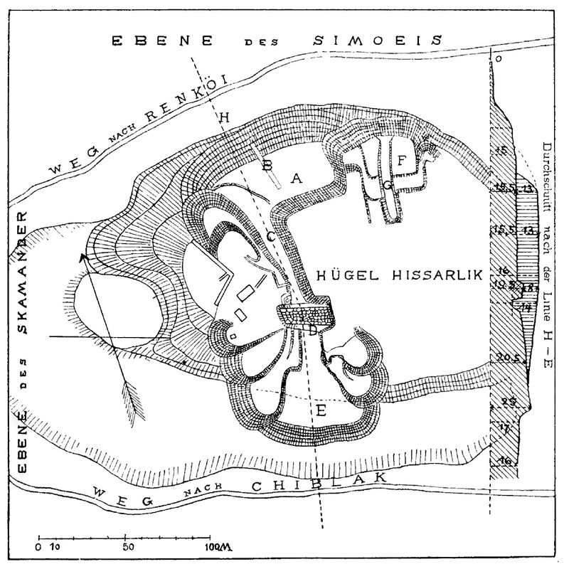
Fig.2: Final Plan of 1872 excavations at Troy.
In
order to create a large section through the entire hill as quickly as
possible and thus bring Priam's castle, which presumably slumbered deep
in the hill, to light the soonest, Schliemann also had a ditch started from
the south in D9 and DB, which should meet the large northern ditch. The
plan from the Atlas of Trojan Antiquities (Plate 117), which is
repeated here in fig.2, shows how excavations were carried out at that time.
A is the large platform on the north side, C is the northern end, and F
is the southern end of the great intersection. The individual terraces,
in which the excavation was carried out and the masses of earth were
heaped up, can be clearly recognized next to and in front of the
section by the arched heaps of rubble. The wide wall D lying in the
middle of the ditch, the so-called great tower, will be discussed in
more detail shortly.
A little south of this, Schliemann had to build
the ring wall of the VIth layer and the south-east corner of building VI
M (see Plate III), i.e. structures that really belonged to Homeric
Troy. He did in fact find the Maucrecke of layer VI M, but did not
recognize it as a ruin from the Homeric period. For in the Trojan Antiquities
article (p.82) we read: "Today the warden Photiadis has a magnificent
bulwark built of large, beautifully hewn shell limestone stones and
without cement or lime brought to light, which seems to me to be no
older than the time of Lysimachus. It is very much in our way, but it
is too beautiful and venerable for me to dare lay my hands on it, and
it shall be preserved. You can see it just to the left on panel 109."
Although
the photograph reproduced on this plate is very bad, the south-east
corner of the VI M building can be recognized with complete certainty
by its regular masonry and especially by the sharply worked corner.
Unfortunately, Schliemann's intention of preserving the beautiful
corner was thwarted by the Turks, for when he was later absent from
Hissarlik, the magnificent wall was demolished by the peasants of
Chiblak and used to build their houses. On the plan of the excavation
of Schliemann's 1873 excavations (our Fig. 3) it can still be seen, and
also on the later plan drawn by Burnouf (Ilios,
plate I; compare our Fig. 4) as Greco-Roman wall indicated. When I went
to Troy for the first time in 1882, it was no longer there
In June 1872, before the great cut through the whole hill was
finished, Schliemann began a second 30 meter wide cut further east on
the northern slope of the hill, namely in GH 2 — 3. On the plan in our
fig.2 is the new workplace marked with F. Since this spot was right
next to and below the Roman Temple of Athena, several parts and
sculptures of the temple were first found, among them the well-known
metope with a relief depicting Helios. Later the ashlar foundations of
the temple, insofar as they were still preserved, must have come to
light; however, they were demolished to allow the deeper structures to
be uncovered. Only a small piece of the foundation remains now.
Schliemann's excavations in 1873.
In
order to further uncover the "great tower" and the city wall to which
it belonged, excavations were resumed in February 1873 and continued
until June. The results of this third campaign can be seen on the two
plans N" 214 and 215 of the Atlas of Trojan Antiquities. I have repeated the first part of them in fig.3 below in a redrawing.

Fig.3: Plan of 1873 excavations at Troy.
First
he traced the "great tower" to the west and found the second level gate
(H in fig 3, and FM in C6 on Plate III). He interpreted it as a "Scaean
gate" (Altertume,
p. 272).
Beside and above the gate some houses of a younger layer are drawn on
the plan, some of which he had demolished in order to be able to
uncover the gate. In the walls drawn next to the gate he believed he
could recognize the "Palace of Priam" or the "House of the City Chief",
because in their vicinity he found the famous great treasure, which he
in the freedom of his discovery held to be the "Treasure of Priam". In
reality, however, as Schliemann himself later acknowledged, the gate
belongs to a different stratum than the house consisting of small
rooms, namely to the prehistoric castle II, while the house, which was
only built above the Ruins of the IInd layer, must be considered as
part of the far more modest settlement of stratum III.
The
great treasure did not belong, as Schliemann believed, to the IIIrd
Layer, but undoubtedly to the IInd and was most likely walled up in the
castle wall made of mud bricks. What Schliemann had earlier suspected
about the find spot he himself later retracted (cf. Troja 1882, p. 64).
We can conclude from the circumstances of the find that the treasure
was installed, as they are presented in the Antiquities
(p. 289) and have also been described to me several times by
Schliemann. The numerous objects of gold, silver, and copper were found
in a square heap atop the stone curtain wall and within a
four-foot-thick layer of red ash and calcined debris. Since later
excavations were able to establish that this red ash, so often
mentioned by Schliemann, was half or fully burned masonry made of mud
bricks and wood, which once stood on the stone substructure of the
castle wall and is still preserved in some places, so it can be
considered certain that the upper wall made of mud bricks at the site
where the treasure was found was still intact and that the great
treasure was built into it. Cavities could easily be created in the mud
brick wall, which was several meters thick.
Schliemann then
dug east of the "big tower" and found there a house consisting of
several rooms, in which a number of large pithoi came to light (see Ilios,
fig.8). It is not exactly clear to which stratum this house must be
ascribed. Based on the depth information and the good condition, I
believe it to be layer III, but it is not impossible that it belongs
to IV. An older, thicker wall underneath, which Schliemann then took
for an inner castle wall (Q in our fig.3 and b in fig.4), later turned
out to be one of the side walls of the older city gate of the 2nd layer.
Further
east he dug a long ditch to the south-east corner of the hill. It
should have hit the stately arched wall of the Mycenaean period (layer
VI) in this fine cut, as one might think. Despite its good condition,
he did not find it because the excavation did not go deep enough.
Only
the higher northern ashlar wall (T in fig.3) of the small Roman theater
B was reached, and taken to be part of the Greek ring wall of Lysimachus.
The foundation of the Propylaion to the Hiero of Athena (R in fig.3)
and the adjoining southern border wall of this Hiero were also
uncovered and erroneously declared to be a water reservoir (Antiquities,
p.224) and the foundation of the Temple of Athena. The latter
designation was prompted by a manuscript found here, in which the
sacred precinct of this goddess (to hieron) is mentioned. Schliemann translated hieron
as temple and therefore believed the building found earlier in the
north, which he had until then thought to be the temple of Athena , now
having to declare it a temple of Apollo, taking into account the Helios
or Apollo metope found there.
A third excavation took place on
the north side of the hill, where several houses of the IIIrd and IInd
layer listed on the plan N 214 of the Atlas
(our fig.3) were uncovered. However, given the discovery of the old
south-west gate and the great treasure, understandably, these
excavations on the north side soon receded into the background. On June
17 [1873], Schliemann completed his third Trojan campaign.
He
thought he had finished his work, because in his diary we read that he
was about to stop excavations at Ilion forever. In his opinion, the
Scaean gate, the great tower, the Trojan ring wall, the house of Priam
and the sacrificial altar of the Ilisian Athena had really been found,
and the Trojan question was finally solved.
How he conceived
the castle of Priam and the enlarged Greek castle of Lysimachus at that
time is shown by the two ring walls in fig.3, which are drawn in
different ways. What he believed to be Priam's Pergamum is essentially
what was later recognized as a prehistoric castle; only he drew the
eastern ring wall a little too far to the east. And what he regarded as
the castle of Lysimachos coincides, on the whole, with Castle VI of the
Mycenaean period, that is, with the real Pergamum of Priam; only here,
too, is the east wall pushed out a little too far. However, there are
not pieces of the VIth layer that he had connected to form a ring of
walls, but rather corners and sections of walls, most of which belonged
to different Roman buildings. Only wall O (fig.3) really seems to have been a
piece of the ring wall of level VI.
It was
therefore an inaccurate picture that Schliemann and his colleagues had
gained from the excavations of Homer's Troy and the city of Ilios in
Greek times. Fortunately the conclusion of the excavations in 1873 was
not definitive. The picture was soon corrected by new excavations.
After the publication of the Trojan Antiquities and the accompanying Atlas,
Schliemann had first carried out small excavations in Ithaca and then
moved to the castles of the Argive plains. In Tiryns he dug without
great success, but in Mycenae he found the fabulously rich royal tombs
inside the castle. No sooner had the results of this work been
published in the book Mycenae
than he was drawn back to Troy. We do not know whether he hoped to find
similar tombs in Troy as in Mycenae. In any case, we meet him again in
Hissarlik in the autumn of 1878 and can conclude from the great
preparations he had made for the new campaign (see Ilios, p.61) that he continued the excavations on a desired large scale.
Schliemann's excavations in 1878-9.
He
first dug again in the vicinity of the south-western gate and the
Priamos house, where he had previously found the great treasure, and
was also fortunate enough to discover some smaller "treasures".
Although the winter rains soon forced him to stop the fourth campaign,
but after a short break we find him again at work in March of the
following year (1879). For this fifth campaign he had the support of
Rudolf Virchow and E. Burnouf, the former director of the French
Archaeological Institute in Athens.The treasure digger of the first
Trojan campaigns had meanwhile become a scientific excavator who
considered it his duty to ensure careful professional examination and
accurate recording of the ruins and layers of earth uncovered with care.
We cannot go into detail here about the rich scientific results of the new excavations; this is reported in detail in the book Ilios,
published in 1881, to which Virchow and Burnouf had made valuable
contributions. With the help of these outstanding archaeologists,
Schliemann was able to distinguish and separate the various settlements
that left building debris and other remains on Hissarlik for
investigation. Seven layers lying one on top of the other were
recognized and he now called them seven "cities". He called the five
lowest prehistoric, the higher historic. Among the latter he
distinguished a Lydian settlement (VI) and an Aeolian or Greek (VII).
Of the prehistoric ones, the middle (III) was considered Homeric Troy.
Instead of the earlier smaller plans, a new large plan drawn by Burnouf
(Ilios, Plate I) and several
valuable sections were published. I have reproduced the plan, in which
the prehistoric and historical ruins are distinguished by different
types of drawing, in fig.4. The prehistoric walls are all black, the
younger ones lighter.
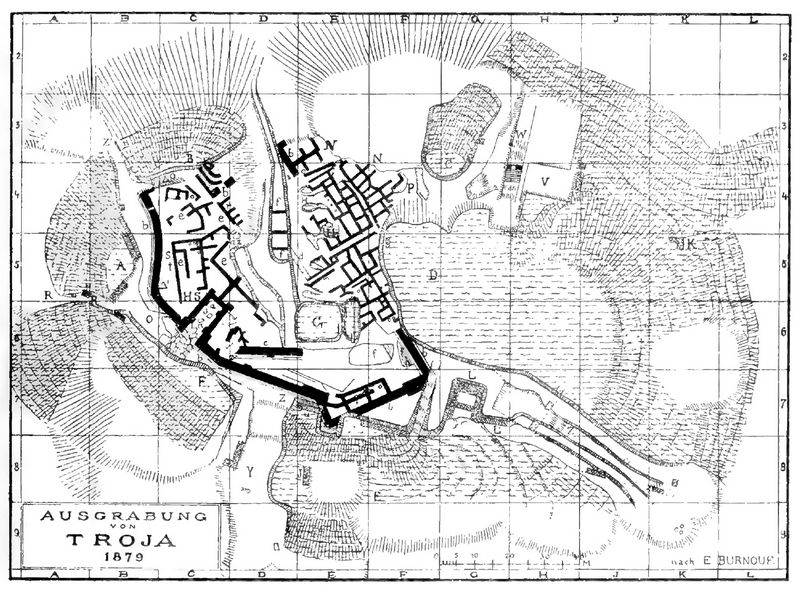
Fig.4: Plan of 1879 excavations at Troy.
A
comparison with the older plan (fig.3) best shows us the advances that
are due to the excavations of 1878-1879. Almost the entire western half
of the old castle has been uncovered. The south-western castle gate (a)
is adjoined to the left and right by fortress walls (b), which can be
traced over a longer distance. The "big tower" of the earlier plans no
longer exists; in its place are now two separate castle walls (b and c)
entered, which had earlier erroneously been taken to be a single thick
wall. On the other hand, a large tower-like projection is now drawn a
little further to the southeast, which later turned out to be an older
castle gate.
The large north-south ditch, which we know from the
older plans, has been excavated a little further and shows several thin
walls (f) of the 1st or lowest layer, the oldest settlement in
Hissarlik, in its depth. East of this ditch we see a large
number of small chambers and corridors drawn, which, despite their
small dimensions and their simple construction, were considered by
Schliemann and his employees to be dwellings and streets
of Homeric Troy. In the eastern part of the hill only slight changes
from the older plan are to be noticed; little had been dug there.
Soundings were also carried out outside the Acropolis, on the adjoining
plateau on which the Roman city of Ilion once stood and where almost
the only remnants of the historical layers were found.
Schliemann
concluded from this that prehistoric Troy was limited to the Acropolis
hill and only the Hellenistic city of Lysimachus extended further over
the plateau. Of the work done in 1879, the investigation of the
numerous burial mounds that largely surround Ilion and that are laid
out on the mountain ranges by the sea were of particular importance.
These are the well-known tumuli, which in ancient times were believed
to be the tombs of Achilles, Patroclus and other Greek and Trojan
heroes. At that time, several of them were explored with a spade and
the objects discovered in them proved that they were partly prehistoric
and partly historical. Schliemann did not find any real graves in any
of them and was therefore inclined to take them all for cenotaphs.
The rich results of 1879 and their detailed publication in the book Ilios
seemed to have solved the Trojan question, and Schliemann's youthful
dream seemed to have been fulfilled. Nevertheless, he soon took up his
mission again. Immediately after the publication of the book Ilios
the tireless researcher on 1 March 1882 returned to Troy for a new
excavation campaign. Serious doubts had been expressed from various
quarters as to whether the small huts of the IIIrd layer, which was
described in the book Ilios
as the Homeric Troy, could really be the dwelling houses of King Priam
and his sons. Schliemann himself "had concerns about the expansion of
the city". It seemed to him impossible that "Homer could describe Ilios
as a large, well-built city with broad streets, when in reality it was
only a very small town". Those concerns were the ones who put the spade
back in his hand. Since the new excavation was primarily concerned with
examining the buildings as precisely as possible, he secured the help
of two architects, Mr. J. Höfler from Vienna and the present author.
Excavations in 1882-1883.
Digging went on for five months, and as the most important result of our work, it was possible to prove in the book Troy,
which appeared the following year, that those doubts in the main were
justified. The Tier III houses, which Schliemann and his associates had
taken for the houses of the royal castle in 1879, were just small
shacks built over the rubble of an actual tier II royal palace. When
the walls of the small houses were partially broken down, strong walls
and mighty rooms of a building complex appeared underneath them, which
we initially took for several temples because of their ground plan, but
soon recognized as the residence of the ruler and his family.
Unfortunately,
the work of the architects was very hampered by the Turkish Comraissar
and the rest of the Turkish authorities. Fearing that we architects
would like to record the modern fortifications of Kum-Kaleh, some six
kilometers from Hissarlik, we were forbidden to measure and draw within
the excavation field. Despite all the requests that Schliemann made to
the Turkish and German governments, it was not possible to reverse the
senseless ban. So it was not possible until the end of the excavations
to draw up a plan of the uncovered buildings (cf. Troy
1882, p. 13). Permission was only granted several months later, when
Herr von Radowitz had become German ambassador in Constantinople, and I
was allowed, under the supervision of two Turkish officers, to measure
and draw the floor plan of the castle that was published on Plan VII of
the book Troy, and in our fig.5 is repeated. Without this subsequent permission, the book would have had to appear without a plan.
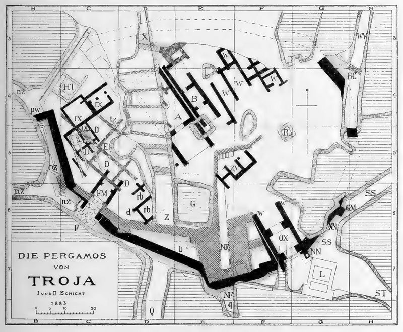
Fig.5: Plan of 1883 excavations of Troy Layers I and II.
Without
going into more detail about the results of the work in 1882, it may
only be mentioned here that first the ring wall of the second castle
was uncovered and examined over a larger stretch, and then an attempt
was made to draw its entire course into the plan based on assumptions .
In addition to the well-known west gate, two new gates of the castle
were found in the south and south-east, one of which belonged to an
older building of period II. Inside the castle we found several of the
uncovered buildings very well preserved.
It
was also possible to
supplement the ground plan here; they showed the plan of the simple
Greek temples with cella and pronaos and could therefore be either
temples or dwellings. Only later, when the Megaron of Tiryns Castle was
excavated, and thus the shape and location of the ruling house of the
heroic time had become known, the Trojan buildings could definitely be
declared residential buildings. In the case of other buildings, an
addition and identification was not possible because of the great
destruction. That the buildings inside the castle had undergone just as
extensive conversions as the castle wall and the gates, and that
therefore at least two periods had to be distinguished for them as
well, could be determined with certainty from the existing ruins.
In
1882 special attention was paid to the most recent buildings, those of
the Greek and Roman periods. We collected and drew the parts of the
great temple of Athena and some other buildings, the remains of which
were found partly in Hissarlik itself, partly in the various Turkish
cemeteries in the area; and recognized the gate building of the sacred
precinct of Athena and were able to see its ground plan and elevation
in the drawing. By conducting a small excavation, we also sought
information about the stage building of the large theater outside the
castle. Unfortunately, this architectural work was
also interrupted by the above-mentioned objection of the Turkish
commissar. Only a
few drawings that had already been made could therefore be published in
the book of Troy.
If,
in order to complete the overall plan of the excavation site and the
individual measurements and drawings, it would be highly desirable to
resume the excavations with a better permission, another reason soon
came up that made Schliemann and myself urgently obliged to continue
the work and investigations.
Since 1883, An artillery
captain, D. Ernst Bötticherm had published several essays and pamphlets
in which he tried to prove that on Hissarlik there were not still temples and castle walls, but only the remains of
a large cremation facility, a "fire necropolis". Although he had never
seen the ruins, he judged the various buildings with an enviable
certainty, called my plans figments of the imagination, and finally
went so far as to assert that the plan of the book of Troy, which
contradicted his theory, had been deliberately falsified by me.
Schliemann and I were alleged to have made large halls out of the small chambers
of the incinerator by demolishing intermediate walls!
Since we
were convinced that ßötticher would easily be disabused by appearances,
Schliemann decided to continue the excavations and to invite him to
visit. Bötticher complied with the request and appeared in Hissarlik in
December 1889 to examine the ruins with us in the presence of expert
witnesses. Such persons appeared at Schliemann's invitation: Major
Steffen from Berlin, known for his excellent maps of Mycenaean and
Attica, and the professor at the Technical University in Vienna G.
Niemann, who had directed the excavations of the Austrians in
Saraothrace as architect. After lengthy negotiations, of which a
protocol was recorded (Hissarlik-Ilion, 1890), Bötticher felt compelled
to withdraw his slander and in particular the accusation of distorting
the excavation results and to declare that he had not wanted to accuse
me of mala fides. However, when he refused to publicly ask Schliemann
and me for forgiveness for his frivolous and defamatory accusations, we
broke off the negotiations (1890 Report, p. 31).
While
Bötticher, having returned to Germany, resumed his incinerator theory
and tried to spread it, the excavations in Troy were resumed by
Schliemann and myself on March 1, 1890. At the same time, at
Schliemann's invitation, a larger international commission of
archaeologists met in Hissarlik and, after a thorough investigation of
the facts, declared that in no part of the ruins any signs of cremation
could be found, and that the plans published corresponded fully to the
actual condition of the ruins (1890 Report,
p. 6.). When Bötticher continued after this statement, not only to
declare all the ruins of Hissarlik to be a fire necropolis, but also to
slander Schliemann and his associates, we no longer deigned to answer
him. Even after Schliemann's death I have ignored his further attacks
and slanders, only publicly declaring that I consider it beneath me to
answer even a word.
Excavations in 1890.
Excavations which began in March 1890, were continued with
numerous workers and for the first time with the help of a field
railway until the end of July. Their scientific results are presented
in a preliminary report published by F. A. Brockhaus, Schliemann's last
work before his sudden, unfortunately much too early death. Immediately
after the end of the excavations, the report was written partly by
Schliemann himself and partly by me and was about to be printed when
Schliemann fell ill with an ear ailment after an operation and was
snatched from us by death on December 26, 1890 in Naples.
The
report appeared soon after with a foreword by the now widowed Sophie Schliemann. It
contained an exact new plan of the excavations that I had drawn up,
which is repeated on Enclosure N 3. A comparison with the older plan
(fig.5) clearly shows the results achieved in 1890. The castle wall of
the IInd layer on the east side of the hill was further uncovered; on
the whole south side three different walls of the second layer could
now be distinguished, which corresponded to three successive periods.
The castle was in each new period several meters to the south. A fourth gate was added to the three gates in the
south-west, which belonged to the first period of the IInd layer. Deep
excavations of the same three construction periods have been
discovered. Under the floor of the previously known buildings of the IInf
layer, the foundations of even older houses of the same layer were
preserved and joined together in some places to form understandable
floor plans. These older houses also had to be attributed to two
different periods.
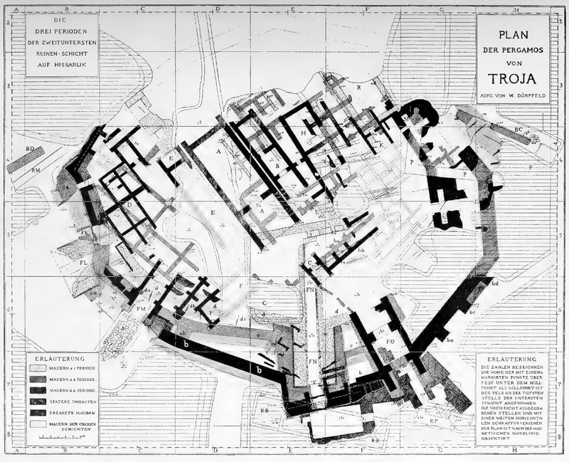
Photo 3: Plan of 1890 excavations. (p.16)
A
special excavation that Schliemann had carried out outside the wall
circle of the IIL layer immediately in front of the southwest gate in B
6 was of decisive importance for the correct knowledge of all the ruins
dug up to that point. There he hoped to find the long-sought
royal tombs deep under the rubble on the rocky ground, because,
following the analogy of Mycenae, he considered it probable that the
inhabitants of Troy had buried their dead close to the gate.
At
the same time, this excavation was intended to serve to examine the
various layers of buildings on a smaller site that had been erected on
the hill above the IInd layer over the course of many centuries (report
1890, p. 57). There appeared, in fact, seven superimposed strata of
structures, which were individually drawn and photographed. After the
destruction of the second layer castle, seven different settlements
were built one after the other until the Roman period.
Even
then, in the middle of these building layers, it seemed to us that layer
VI was deserving of our special attention. At that point it contained
the remains of two large buildings which, by their dimensions, the
quality of their construction and the strength of their walls, were
distinguished from the buildings of all other strata. A ground plan of
one of these buildings could be published on p. 59 of the report,
showing the shape of a Greek temple or an old dwelling house, a
megaron.
The importance which we thought we had to ascribe to
the two buildings was increased by the fact that the objects which were
found in and near them can be dated to some extent and point to the
Mycenaean period. In addition to monochrome, mostly gray pottery, which
Schliemann had previously described as Lydian, several vases and vessel
fragments of the Mycenaean type came to light, i.e. objects that can be
attributed to around the second half of the second millennium BC. Such
vases had never been found in the lower layers.
We were then
able to conclude that those stately buildings must have existed at a
time when Mycenaean pottery was still common, so they had to be
ascribed to the second millennium BC or at the latest to the beginning
of the first. At the confirmation A. Brückner, at that time a
scholarship holder of the German Archaeological Institute in Athens,
whom Schliemann had summoned to study the vases in Troy on my behalf,
provided us with this fact very valuable help.
How could those
unexpected facts be explained? Did we find one or even two temples here
that were built in prehistoric times over the ruins of the second layer
after the destruction of the Homeric castle of Troy? Or could the two
stately buildings that were found be the inner structures of a larger
castle, whose ring wall was further to the outside, and had not yet
been found? Should one of the previously discovered walls previously
thought to be Greek be the castle wall of this VI or "Mycenaean"
layer? And if this was the wall, mustn't the 2nd layer be much older
than the Trojan War, and cede the honor of being Homer's Troy to the
6th layer? These important questions, which of course kept us busy and
are also indicated at the end of the report on the excavations of 1890
could only be answered by further excavations. Schliemann did not live
to see the solution to the problem; the questions accompanied him into
the grave unanswered.
2. The Work of 1893.
After
Schliemann's death, it fell to me, as his long-standing collaborator,
to continue the work in Troy and to bring about the solution of the
still existing and new questions by the spade. Frau Sophie Schliemann,
who had been a faithful companion of her husband during the work in
Troy and herself had dug up the "treasure of Priam" with him, kindly
made the money available for new excavations. She considered it her duty
to have the work completed in the spirit of her husband. We owe it to
Richard Schoene and Rudolf Virchow in particular that the excavations
interrupted by Schliemann's death could be resumed in the spring of
1893.
At my request, the Royal Prussian Ministry of Culture sent
Messrs. A. Brückner as archaeologist, R. Weigel as prehistorian and W.
Wilberg as architect to Troy to support me in the management of the
work and in the study of the finds. In a three-month activity, we tried
to solve the tasks assigned to us together.
We published the results of these new excavations and studies in the following year in the book Troy
1893. In it we were able to give the important information that the
sixth layer, in which the remains of the two stately buildings and the
vessels of the Mycenaean style had been found in 1890, actually
contained the ruins of a mighty castle complex of the Mycenaean period,
a castle which now could, with security, be declared from the Troy sung about by Homer.
We succeeded in discovering several other
large buildings and a mighty fortress wall of the VI stratum, and at
the same time in finding numerous objects which left no doubt as to the
dating of the VI stratum. In Mycenaean times there was a stately castle
on the hill of Hissarlik, the ruins of which had hitherto remained
unnoticed and buried, although some of them were in a better state of
preservation than the remains of the other strata.
The castle of
the second layer, which we had previously assumed with Schliemann to be
Homeric Troy, now had to be ascribed to an older prehistoric period.
Indeed, it was separated from the Mycenaean layer by three layers of
settlements and must therefore be considerably older than this. What it
lost in importance because it was no longer allowed to count as Priam's
castle, which Homer sang about, gained it to a greater extent because
it now became a pre-Homeric or prehistoric Troy and thus had to be
ascribed to a far distant time, a period from which we have no other
ruins, or at most very insignificant ones, in Europe and Asia Minor.
It
was a strange fate that Schliemann did not find the stately buildings
of the VI layer during his earlier excavations and did not recognize
their true meaning at the two places (in D8 and in K5) where he had
accidentally come across them. To the casual observer, it even seems
incomprehensible at first that Schliemann could excavate an older
castle and overlook a younger, higher-lying complex with massive walls
and buildings. But anyone who studies the ruins of Troy more closely
will soon understand this fact as a consequence of the peculiar terrain
conditions on the one hand and Schliemann's excavation method on the
other. On the north side of the castle hill, where the ring wall of the
sixth layer had been completely destroyed in antiquity, Schliemann had
made deep cuts in the slope. If the castle wall and the inner houses of
the sixth layer were still there, he would not only have found and
admired them, but probably also recognized them as Homeric buildings.
Unfortunately,
on the south side of the hill, its ditches did not go down deep enough
to find and recognize the castle wall. What he saw here of the circular
wall was only the superstructure, which had been badly damaged and
rebuilt; it was too insignificant to give Schliemann the idea that what
was left of a particularly stately castle lay here. A corner of the
inner building VI M had, however, come to light and, as we have seen,
aroused Schliemann's admiration; but because of its good construction
the wall had been ascribed to historical times. Also in the north-east
ditch in K 5 the upper part of the castle wall of the sixth layer was
cut through
but the ditch was so narrow that it was not possible to make a reliable judgment about the age, purpose and extent of the wall.
In
addition, until 1890 the excavations had been limited almost
exclusively to the core of the hill, because that was where the small
prehistoric castle had first been discovered and the treasures found.
In the middle of the mound, however, as we will see later, almost no
remains of the VI layer were preserved, and the outer parts and the
slopes of the mound, under which the buildings of the much larger
Mycenaean castle lay, were almost completely excavated remained
untouched. Only when a large area outside the IL castle was excavated
for the first time in 1890 did the two buildings VI A and VI B come to
light. Only they led to the discovery of the VI layer, the true Homeric
castle of Troy.
One need only glance at Plan I of Troy 1893
to see how much the picture of the ruins uncovered had changed as a
result of the 1893 excavations. It is true that the floor plan of the
layer II castle is only enriched by small additions in the north-west
corner
and in a few other places; but all around individual pieces of a new,
larger ring wall and inside several buildings of large dimensions have
been added, which form a large castle complex of the Mycenaean period.
And
above these venerable ruins the remains of Greco-Roman buildings are
shown on the plan, most of which belonged to the sanctuary of the Ilian
Athena. Schliemann's earlier assumption that in historical times there
was a temple of Apollo on the north-east corner of the hill and a
temple of Athena on its south side was not confirmed. Rather, it was
established that in Roman times the entire eastern half of the
Acropolis hill was occupied by the sacred area of Athena. The
Propylaion (in G7), discovered earlier, had provided the entrance to
this sanctuary. Parts of the foundations and several structural
elements of the temple itself had still been found. Also belonging to
the Roman period is a small theatre-like building (Theater B), the
ruins of which have been uncovered at the south-east corner of the
hill. Between the remains of the Homeric castle and the higher Roman
ruins numerous walls of Greek times were also found, which had to be
assigned to two different settlements. After the destruction of the
Homeric castle, there had been dwellings here at different times and
had been buried and built over when the great Hieron of Athena was
erected.
These results of excavations and investigations shed
the desired light on the history of the many settlements that had
formed one upon the other on Hissarlik Hill over the course of
thousands of years. The collaboration of architects, archaeologists and
prehistorians had solved some problems. The many buildings, as well as
the numerous finds made of stone, clay, metal and other materials had
been examined more closely and had thus made possible a fairly easy
separation and dating of the various settlements. The political history
of Ilion had also been further clarified by new marble inscriptions.
In the book Troy 1893
an approximate dating of the nine most important layers on the castle
hill of Ilion could be attempted (p. 86) and their construction,
destruction and expansion illustrated by a schematic cross-section (p.
35). We would have liked to have continued the excavations in the
summer of 1893, but the summer heat on the one hand and the consumption
of funds kindly granted by Mrs. Schliemann on the other hand forced us
to end the campaign, the first in which Schliemann had not taken part.
3. The excavations of 1894.
The
excavations carried out up to 1893 proved that more or less significant
remains of nine different settlements, which had existed in this
privileged place of the Skamander valley since ancient times, were
preserved on the Hissarlik hill. It was also established that of these
strata the five lowest (I - V) came from prehistoric times, that the
following (VI) belonged to the Mycenaean period sung by Homer and the
three higher ones (VII - IX) belonged to the younger Greek and Roman
epochs. The prehistoric settlements were carefully examined by
Schliemann's excavations, the Greco-Roman ruins were also thoroughly
explored, but we didn't know very much about the most important layer,
that from Mycenaean times. Although several interior structures were
found in 1890 and 1893 and the presence of a strong castle wall was
established to the east, south and west of the hill, the exact course
of the wall, its gates and towers were not yet known, and neither were
the interior structures studied as their importance required. It was
therefore urgently necessary to further elucidate the remains of the
important VI layer that had already been found by means of new
excavations and to seek out and uncover other ruins of this layer.
When
we left Troy after the completion of the work in 1893, it was with a
fervent desire to return as soon as possible and to complete the
excavation of the VIth stratum. Our wish was to come true
sooner than we dared to hope at the time. In August, 1893, in Potsdam,
I was permitted to make an oral report to His Majesty the German Kaiser
Wilhelm II on Troy and its excavations, and to present lithographs and
plans of the ruins that have been preserved. His Majesty not only
showed the keenest interest in the famous ruins, but also promised to
provide the necessary funds to continue the excavations. In fact,
during the winter of 1893/94 I received a letter from the German Reich
Chancellor with the highly gratifying news that His Majesty the Emperor
and King had given 30,000 marks from the funds for the excavations in
Hissarlik and for the publication of their results by the German Reich
and the Prussian State.
Through the kind mediation of the German
Embassy in Constantinople, the permission granted by the Sublime Porte
for 1893 was extended for another year, and so the excavations could be
resumed in the spring of 1894. So that the management and supervision
of the work can be carried out as professionally and thoroughly as
possible, and the observation and processing of all finds can be
carried out as carefully as possible, I again recruited several
collaborators for the various areas of archaeology. Unfortunately, A.
Brückner, who had been an archaeological member of our expedition in
1893, was unable to take part in the excavations for personal reasons.
The prehistorian M. Weigel was also unable to take part due to a
serious chest disease from which he had been suffering since 1893; we
even had the pain of learning of the death of this gracious and
talented collaborator just as we had begun the new dig. Only the
architect, W. Wilberg, was my assistant again from the earlier
collaborators. The two archaeologists H. Winnefeld and H. Schmidt stood
in for A. Brückner and the prehistorian A. Götze took part in the work
in place of Weigel. As commissar of the Ottoman government, the
official of the museum in Constantinople, Achmet Bey, was present
during the excavations; we are indebted to him for the proper
supervision of the work.
We hired two Greeks to oversee the
workers, Georgios Paraskevopulos from Olympia, who had already worked
as an overseer in Troy under Schliemann and had served me well in
almost all my excavations for many years, and Konstantinos Kaludis from
Athens, who unfortunately fell ill and has since passed away. The
photographer of the German Archaeological Institute in Athens, R.
Rohrer, was again persuaded to photograph the layers of earth, walls and
finds; he made several hundred recordings, a list of which will be
published at the end of this book. The average number of workers was
120. They were mostly the same people from the surrounding villages who
had worked in Troy under Schliemann. Some of them still bore the
Homeric names assigned to them at the time. One called himself
Agamemnon, another Odysseus, a third Achilles, and they proudly called
their "Here" when the list of workers was read out and these famous
names were called. Only a few Turks were among the workers, the great
majority being Greeks.
After the overseers had traveled to Troas
in mid-April to make all the preparations for the start of the
excavation, we ourselves arrived in Hissarlik on April 27th and were
able to start work immediately. During the months of May and June the
excavations continued uninterruptedly, but in July, as the summer heat
increased, not only did a great many workers fall ill with the fever,
but all my co-workers were seized with the nasty malarial fever. So we
were forced to stop digging in mid-July. We would have closed 8 days
earlier if we hadn't had the duty of bringing the excavations, which
were initially not to be resumed, to a temporary conclusion. With two
columns of workers we attacked the hill from the east and west,
followed the line of the castle wall from both sides and only reached
the main gate of the VI layer Castle. Without its exposure our work would
have been incomplete. Only when the gate was uncovered and the entire
line of the wall was determined were we allowed to put down the spade.
In
a 12-week strenuous work schedule, we had completed the task set before
us. Significant remains of the castle of the Mycenaean period, the
existence of which we had only suspected in 1890 and proved to be
certain by the excavations of 1893, now lay before our eyes. A mighty
ring wall with strong towers and several gates and a number of interior
buildings were brought to light. All the structures found were indeed
badly damaged, but the substructures that were preserved showed such
excellent construction and in some cases stood higher than we had ever
expected. In view of these stately ruins, especially the beautiful
retaining walls and the mighty castle wall, there was no longer any
doubt: these were the walls and towers that Homer sang about, here was
Priam's castle. Besides the ruins of the VI layer, we re-examined the
walls and soil layers of all the other settlements, which were proved
by the older and more recent excavations on the Hissarlik hill. What we
found here will be detailed in the next chapters. Only a brief overview
of the most important systems can be given here.
At
the top we had found the remains of large Roman buildings (IXth layer):
a temple, several theatres, colonnades and a gate building. They were
almost all destroyed except for the foundations. Their marble building
elements lay partly in Hissarlik, partly in the Turkish cemeteries of
the surrounding area. Among the Roman structures were two layers of
simple dwellings from the ancient Greek period (VIII and VII). Some of
its walls still stood several meters high; they had been buried during
the construction of the Roman acropolis without being completely
destroyed.
At a still greater depth we had discovered an older
layer (VI), which contained the ruins of a strong castle and certainly
belonged to the Mycenaean period, that is, to the time of the Trojan
War. Deeper still, in the central part of the hill, another three
layers of poor settlements (V, IV and III) had been found earlier, and
below these prehistoric villages lay that small castle (II) formerly
thought by Schliemann and myself to be Homeric Troy was, but had now
turned out to be an older prehistoric castle complex.
As long
as it seemed to be the only pre-Greek castle on the site of the later
Ilion, its claim to be the Troy sung about by Homer could not be
denied. But now that a Mycenaean castle had been found above it, it had
to relinquish its prerogative, but as an ancient, prehistoric castle of
Troy, it was allowed to claim our full interest. We therefore continued
to excavate and examine a small part of the second layer in 1894, a
work that was specially directed by A. Götze.
From an even
older settlement, level I, small building remains and many everyday
objects were found below the prehistoric castle. Since they were
particularly important for prehistoric science because of their old
age, we uncovered a small piece of this layer on the northern slope of
the hill.
However, our work was not limited to the castle hill
itself; We also undertook smaller excavations in several places in its
vicinity, namely within the later historical city of Ilion. First of
all, we wanted to look for remains of the sixth layer outside the
castle, in order to determine whether a lower city had existed
alongside the acropolis in Mycenaean times. Second, tombs of different
periods should be researched in the area. We did not hope to discover
the tombs of the Trojan rulers of Homeric times, for these can
undoubtedly be identified in the tumuli, in those numerous burial
mounds that lie on the hills around Troy and were thought to be tombs
as early as Homer's time. But we had every right to expect to find
simpler graves near the castle. As will be explained elsewhere, we were
not disappointed in this expectation.
Unfortunately, despite our
urgent wish, we were not able to excavate and examine some of the
tumuli in detail, because the Turkish government granted the requested
permission, but immediately revoked it. All our efforts in this regard
have been fruitless. Permission was not granted again, ostensibly
because the modern batteries were too close to the tumuli. We pointed
out that the two burial mounds which we had requested in the first
place to be excavated, namely Ujek-Tepeh (Ilios, p. 732) and Bcsika-Tepeli (Ilios,
p. 739), lie further from the batteries than Troy ourselves, but we
didn't have any success with that either. Admittedly, as we have
already reported, most of the burial mounds of the Skamander Plain had
already been explored by Schliemann, but the wells and ditches he had
dug for their investigation did not, in our opinion, reach deep enough
into the mounds. A more thorough excavation is urgently needed. It must
be reserved for a later time.
Although
the tasks we had set ourselves were essentially solved by our
excavations in 1894, the excavations in Troy have been brought to a
temporary conclusion, but they are by no means over for all time.
Excavations can and must still be made in the Greco-Roman city, the
ruins of which are preserved on the wide plateau next to the castle and
are still buried under the earth. Furthermore, the castle wall of the
VI layer on the south side must also be uncovered. Up to now we have
only freed its upper edge from the mass of rubble and verified through
a few shafts that it still stands several meters high along its entire
length. The Homeric castle would gain greatly if this stately wall
could be uncovered, in whole or at least in part, in its full height,
as we have done with the east wall. The fact that the south wall may
have been equipped with a tower that has not yet been found will be
explained elsewhere. Desirable work is also the construction of a later
retaining wall discovered by Schliemann on the north slope of the
castle hill and the complete excavation of the large well B b in the
north-east tower of the sixth layer.
One could also think about uncovering the unexamined part of
the VI layer in the squares E8 to G9 and when carrying it out one
should count not only on new buildings of the VI layer, but also on the
complete completion of the main entrance to the castle. However, I have
already stated elsewhere (Athen. Mittheil. 1894,
XIX, p. 392) that I consider such work to be neither necessary nor
desirable. It seems to me that it is our duty to leave untouched some
parts of the peculiar hill of Troy, which is so extremely important for
the study of antiquity, so that later generations, who are certainly
even more trained in the technique of excavation and even more careful
in observing the different things will be when we can control and
possibly improve our work through new excavations.
If the whole mound
is now excavated and the different strata do not lie undisturbed on top
of each other at any point, then any later investigation of the ruin
site and any control of our observations is made impossible for all
time. Already Schliemann, wrongly feeling this obligation, left some
cones of earth inside the castle where the younger strata lying above
the 2nd castle can still be seen and examined again, but on the one
hand these cones of earth are too small and in the course of the time
are gradually destroyed by rain, sun and wind, and on the other hand
these places are in the middle of the hill, where nothing or only very
little is preserved from the VI to VIII layers. We therefore thought it
necessary to leave a large area quite untouched on the edge of the
hill, where the upper strata still exist.
Leaving aside those smaller works that are easy to catch up
on, the great work of the excavation at Troy was essentially completed
with the excavations of 1894. The wish with which Schliemann first set
foot in Troas, to find and excavate the Homeric castle, has in fact
been fulfilled, more fully than could ever have been hoped for. On the
spot where the Roman city of Ilion stood with its large buildings,
ruins from the earlier Greek period, stately remains of Homeric Troy,
and many other ruins of even older settlements have been found. Priam's
castle has actually been given back to us, and in addition we have in
it a unique, extremely important ruin site for the study of the oldest
history of mankind.

Plate 2: 1894 excavations at Troy, showing personnel of the expedition.
Two
photographs of the excavations of 1894, which are published in the
appendices to this section, may give a vivid impression. Plate 2
shows the members of our expedition, the overseers and workers at one
of the uncovered buildings of Homeric Troy. Behind the people you can
see the beautiful retaining wall of building M, layer VI, made of large
stones and next to it simpler walls of the younger strata. In the
second picture, the adjacent Plate 4, some workers are shown in full
activity: on the east side of the castle hill, younger walls are being
uncovered over the Homeric castle wall. The excavated earth is brought
in by handcart and poured down the castle wall into small wagons, which
are then taken on rails to the edge of the hill. The castle wall and
its eastern tower can already be seen under the stones and masses of
earth.

Plate 4: The excavation of the eastern castle wall of layer VI in 1894 (p.24)
I
cannot close this chapter on the history of the excavations in Troy
without expressing the hope that a larger part of the lower city of
what later became Ilion will soon be uncovered, and that the tombs of
the ancient kings of Troy will also be examined more closely.
Wilhelm Dorpfeld.
[Continue to Chapter 2]
|
|