|
Excavations on the west slope of the Acropolis.
II. The Lenaion or Dionysion in the Limnai (part 1)
Article originally published in 1895 in the journal Mittheilunger des Kaiserlich Deutschen Archaeologisch Instituts, Band XX, pp. 161-205 (Communications of the German Imperial Archaeological Institute, Athenian Section, vol. 20, abbreviated as Athens Mitth. XX).
Plate 4: Plan of structures in the sanctuary of Dionysius Lenaios.
Now that a general overview of the results of the excavations up to the end of 1894 has been given in Report I (Athens Mitth. XIX p. 496), we here begin the detailed discussion of the uncovered sanctuaries, buildings and water systems with a sanctuary, the Dionysion in the Limnai.
whose uncovering and investigation is fully completed, and which
can claim to be one of the oldest and most important sanctuaries in
Athens.
A part of the district was found in the beginning of
1894 and soon recognized as the long-sought Hieron of Dionysos Lenaios.
The whole sanctuary with its temple, its altar and its wine press was
only excavated in October and November of the same year. In the Roman
period it was completely ruined and overbuilt by a structure which,
according to an inscription found in it, was the meeting house of the
association of lobakchen and was called Baccheion.
We shall first discuss the older ruins, then the younger ones, and finally try to establish the name of the sanctuary.
A. The ruins of the ancient sanctuary.
The
general location of the sacred area in the valley between the
Acropolis, Areopagus and Pnyx is described earlier and can therefore be
assumed to be known (cf. plate 14 of the previous volume). The district
forms a triangle in plan, which was surrounded on all sides by public
roads. The base line, located on the driveway to the Acropolis,
measures about 45m, the greatest height about 25m, so that the total
area of the district is about 560 square meters.
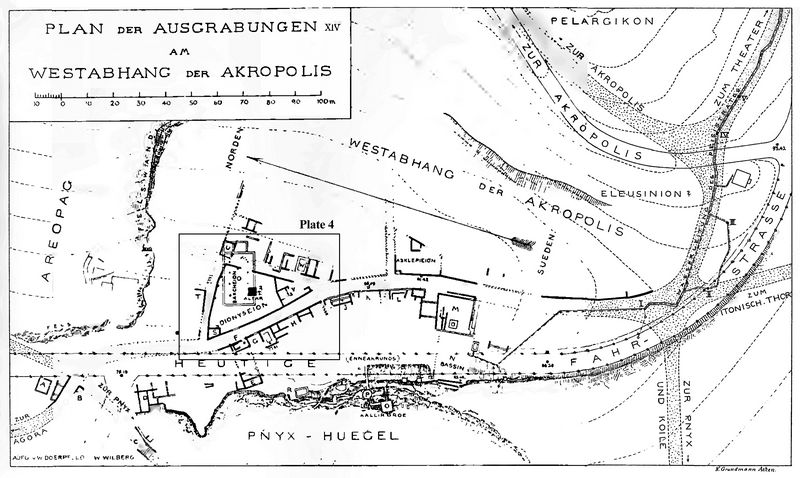
Plate 14: Map of survey region, showing location of sanctuary of Dionysius Lenaios (inset for plate 4).
The structures
that have been uncovered are drawn in different colors and in different
ways on plate 4, depending on their age. They belong in the main to
three periods: 1. The Greek, whose ruins are laid out on the plan with
solid black paint or with black hatching; 2. the early Roman, whose
walls are hatched in red; 3. the late Roman ones, the remains of which
have acquired a full red hue. The ancient streets are again entirely
dotted, as in the earlier plan, and are therefore easy to survey.
Today's driveway is made recognizable by small circles at the lower
edge of the plan, which are intended to indicate the trees. In order to
distinguish the water pipes for fresh water from the numerous canals
for rainwater and house water, those are drawn black and blue, the
latter only black. The drinking water fountains are also colored blue
in the fountains, while the access boxes of the canals are only
indicated by a black circle. For external reasons, the orientation of
the whole plan was chosen in the same way as on plate 14. North is on
the left, east at the top. The inscribed numbers indicate the height
above sea level in metres.
The buildings of the different
periods can be distinguished on the spot with complete certainty, first
by their material and construction, and then by their altitude. In
fact, the ancient Greek structures consist either of hard blue
limestones assembled in a polygonal construction, or of ashlars of
Piraeus limestone (porous); of the more recent buildings, only the
foundations, made of small stones and clay, have survived; the most
recent ones use different kinds of stones (p.163), mostly bonded with
lime mortar. Equally clear is the difference in height of the three
building complexes one above the other. While the floor of the old
district is about 77.25 m above sea level, the floor of the youngest
building, the Baccheion, shows the figure of 79.60 m. The old district
was buried more than 2m high in Roman times, so that the lobakehen, if
they held their meetings in the Bakeheion
in the IInd or IIIrd Century AD, could no longer see that, deep under
their meeting house, was an old sanctuary of Dionysus. How high the
burial had risen by early Roman times. cannot be determined precisely
because the floor of the middle building cannot be seen. It seems to
have been almost as high as in the 3rd period.
We owe the relatively good state of preservation of the
oldest buildings to the low location of the old district and its high
level of burial. They are so well preserved that there is no doubt
about the identification of the individual features of this sanctuary
or hieron, a building with a winepress in the north corner, a small
temple in the south corner and some insignificant assets.
Fig.1: Section of the south end of the western perimeter wall.
The
perimeter wall of the precinct is a retaining wall on almost all sides,
because the interior of the sanctuary was in most places lower than the
outer streets. The difference in height was originally up to 2m and
increased as the roads gradually rose. Only on the north-west corner
was the interior of the district slightly higher than the street. The
wall is built of polygonal blue limestone throughout its length, but is
not of the same construction throughout. In fig.1 a piece of the
southern end of the exterior of the western wall is shown. At
the bottom one sees large, carefully joined polygonal stones; above
that is a fairly good polygonal masonry made of small stones, and at
the top is a piece of poor masonry made of small (p.164) stones, which
must be of a later date. fig.2 shows a piece from the north end of the
same wall, belonging to the west wall of the winepress.
Fig.2: Section of the north end of the western perimeter wall, adjacent to the winepress.
It
differs from the wall shown in fig 1 mainly in that the stones of the
lowest layer are not polygonal, but are cut entirely at right angles.
In the other parts, namely in the north wall and in the middle of the
west wall, there are large and small stones next to each other on the
inside, which gives the building a very ancient appearance. One almost
believes one is looking at a wall of the so-called Mycenaean (p.165)
period if one looks at the wall section shown in fig.3 from the inside
of the north wall. The processing and joining of the stones is not very
careful.
In my opinion, this disparity in the masonry in the
individual parts of the district wall can only be explained by the
assumption of multiple alterations, which have taken place over the
course of the centuries-long existence of the district. A very extensive repair is to be observed in the central and
southern parts of the eastern wall; you can still see a piece of the
older, good enclosing wall and behind it a younger wall made of
different materials. In the plan (on plate 4) the latter is hatched in
black and red at the same time, because it cannot be decided whether it
still belongs to the old Greek district or whether it has to be
ascribed to the older Roman reconstruction.
Fig.3: Section of the inside of the north perimenter wall.
On
the eastern and northern sides of the district, where the enclosing
wall had to withstand a strong ground thrust due to the difference in
ground level, it was supported by buttresses, some of which are still
intact, others only in small remains. Only one seems to have existed in
ancient Greek times; the others, because of their poor construction,
must be ascribed to the period shortly before the old sanctuary was
buried.
No remains have been found of a larger gate building.
Since there is also no trace of a simple gate (p.166) in the course of
the outer wall, we have to look more closely at the gaps in the wall
that now exist to see whether there could have been a gate at one of
them. On plate 14 of the previous year, a gap in the western boundary
wall south of the wine press is drawn and an entrance gate assumed to
be there. The height conditions spoke in favor of this, because the
interior of the district and the street were at the same height here.
However, the recent deeper excavation of the street has shown that the
lowest layer of the wall is still well preserved here and next to it
are the old curbstones, which served to protect the wall against the
passing carriages. A gateway can therefore hardly have lain here. Since
there is no gap suitable for a gate in the north wall either, the
entrance gate at the southern end of the east wall, where the only
large gap is found, must be completed. This place is particularly well
suited for a gate, because the temple faces it with its vestibule, and
because the square in front of the temple is at the same level as the
two streets that meet here. If one had entered the forecourt of the
temple, one could go down to the sacred precinct through the door,
still well preserved, at the north-west corner of the temple. This
seems to have been the only access to the Hieron.
Most of the
substructure of the large altar in the middle of the district, which is
in the form of a table, has been preserved. The stones found, which are
shown in the ground plan below (fig.4), are sufficient to draw the plan
of the entire altar with complete certainty. The substructure assembled
from porous limestone blocks formed a square with a side length of 3.10
m and had four holes, each 0.24 m in diameter and 0.10 m deep, which
once held four small columns as the feet of a table. If, as we may
assume, the cover plate to be added protrudes about 0.20 m over the
feet on all sides, we get a square of about 2.00 m for this plate. At a
later
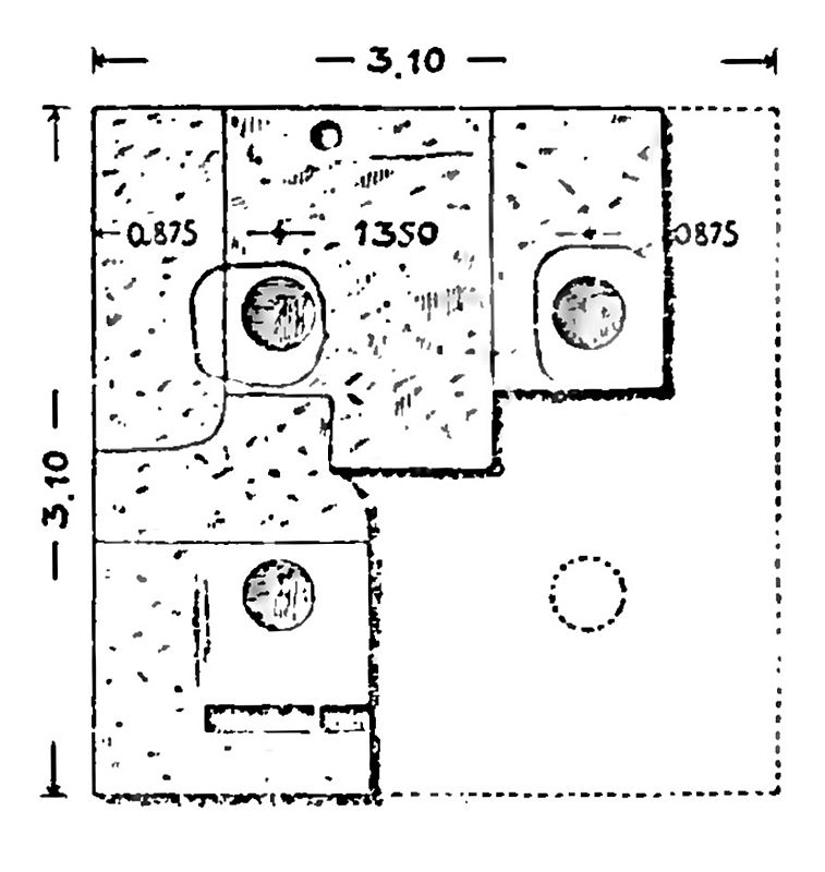
Fig.4: Ground plan of altar.
An
initially very inconspicuous indentation on the substructure offers a
very special interest. In fact, on the western step one notices an
elongated hole 0.49 m long, 0.13 m wide and 0.08 m deep and next to it
the rest of a second similar hole, the other half of which disappeared
with the neighboring block. Anyone who has ever seen the numerous
examples of the inscription stones serving as documents on the
Acropolis of Athens or in other sacred areas cannot doubt for a moment
that those two holes were also used to accommodate stone steles. One of
these steles is, as will be shown later, known from Demosthenes
(Apollodor).
But may we also safely describe the above-mentioned
substructure as the remains of an altar? I do not wish (p.168) to
emphasize that no other acceptable explanation has yet been proposed,
but rather to point out the fact that altars in table form appear on
vase paintings, particularly for Dionysus. The cover plate of a 2.3 m
long and 1 m wide sacrificial table dedicated to Dionusos Auloneus was
also found in Attica (Athens Mitth.V,.
p.116). Finally, a lower stone with 2 round holes very similar to our
structure has been preserved in Eleusis (cf. O. Rubensohn, The Mystery Sanctuaries in Eleusis and Samothrace,
p.196). Its addition to an altar is secured by the inscription, some of
which has been preserved. The explanation of our substructure as an
altar is therefore not subject to any reservations.
We are unable to determine the exact age of the altar. Only so much can be said
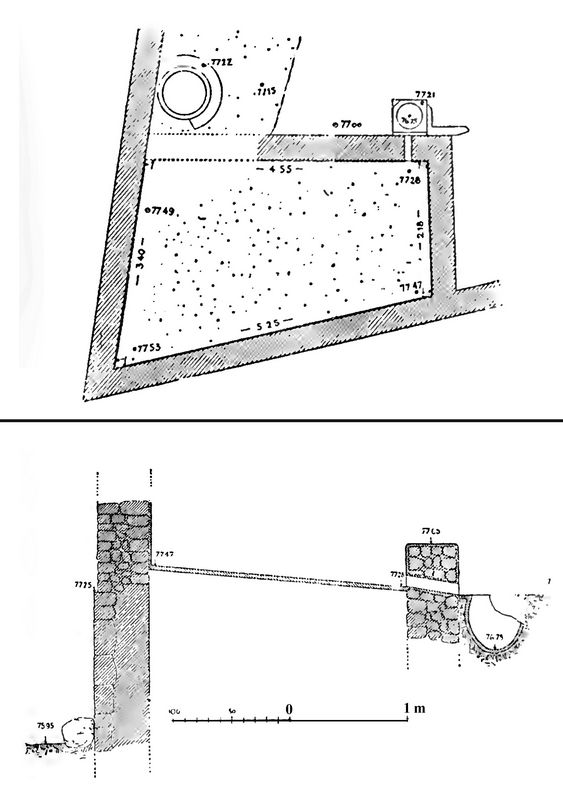
Fig.5 (top): Ground plan of winepress.
Fig.6 (bottom): Section of wine press.
The
building preserved in the north-west corner of the district is
inconspicuous at first, which only has a few thin walls and floors made
of pebble screed, and yet it is not only very valuable in and of
itself, but also of almost inestimable importance for the determination
and naming of the district. The best-preserved room in this building is
in fact a Greek wine press, and the other rooms must also have been
used for wine-making. The ground plan of the winepress (cf. fig.5.6)
forms a somewhat irregular square with an average length of 4.70 m and
a width of 2.80 m. Its interior shows a well-worked screed of river
pebbles and lime mortar, which is not horizontal, but has a steep fall
of 0.25m towards its south-east corner. The east wall is drilled
through next to the deepest point of the floor and in front of the
opening there is still a round thong vessel with a square upper rim and
an inner diameter of 0.50 m and a capacity of around 55 litres. Its
shape can be seen in the (p.169) adjacent cross section through the
wine press (fig 6). Next to the vessel there is a small square
depression made of mortar, the shape and meaning of which can no longer
be recognized because of the severe destruction. While the northern and
western walls of the wine press served at the same time as the border
wall of the district and as (p.170) enclosing walls of the building to
which the wine press belonged, perhaps also carried a roof, the eastern
wall was only 0.35 m high and is still visible today their surface a
plastering with rounded corners, such as is still customary for
practical reasons on such low walls. The height of the southern wall is
not known.
The fact that the room was not a water tank can be
concluded with certainty from the large slope of the floor and the low
height of the east wall. For the same reasons, a living space is also
out of the question. The facility was undoubtedly a wine press. Wine
presses are still made in a very similar way in many areas of Greece
today. A square, paved square is surrounded by low walls, the floor is
given a steep slope, the outer wall is pierced at the lowest point, and
a small brick, stone, or clay vessel is placed in front of the hole so
that the grape juice can pour from the stepping stone into this vessel
run and can be scooped there.
Wine presses were also made in the
same way in the Byzantine period, as evidenced by the numerous wine
presses found in Olympia, which belong to the Vth and VIth centuries
AD. It is well known that grapes were trampled in cellars in antiquity
as well, and this is shown on vase pictures. I owe K. Buresch the
reference to the large presses in the Dionysian procession of Ptolemy
Philadelphia (in Athenaios V 199 a), and to the krathres upolhveos in the inscription of the king of Commagene in Humann-Puchstein, Reisen in Nord-Syrien
p. 215 Z. 25. That clay vessel located near the wine press may then be
called wol krathr upolhnios. With the wonderful tenacity with which the
Greek farmer now holds on to his plow and other agricultural
implements, which were common thousands of years ago, it is not
surprising that the design and equipment of the wine press has not
undergone any significant changes from ancient times to the present day.
{p.171)
To the east of the winepress is a second one, with a room with a
similar floor covering of pebbles, which unfortunately is so badly
damaged that not even its extent can be determined with certainty. Its
purpose is also unknown, although a
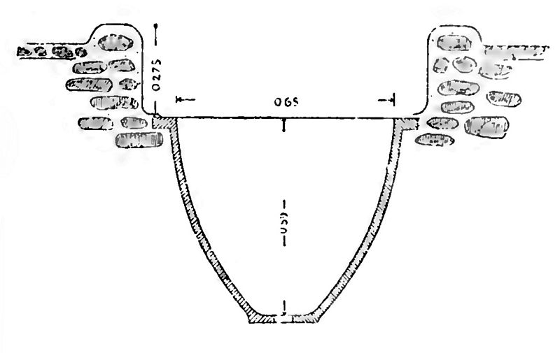
Fig.7: Vessel embedded in floor of second winepress room..
A
third narrower chamber, which contained a gully, is connected to the
south of the winepress. Its floor is destroyed. Next to it is a 1.0 m
deep, brick and plastered container. which was probably connected to a
water pipe and may have served to store the water needed for winemaking.
For
determining the time of the cellar system, it is important that the
front wall of the Lesche, located on the road just opposite the wine
press, shows a very similar design with small stones and also has the
same altitude. Since the Lesche has to be placed in the fourth century
(p.172) on the basis of the found boundary stones with the inscription
HOROSLESCHE, we can also attribute the wine press to about the same age.
At
a later time, a piece of the winepress was cut off, and still later a
completely new, smaller winepress was built on top of the older one
(cf. Plate 4). This occupies a little over a third of the older site
and has a limestone and small pebble soil that slopes to the east. The
vessel that once held the must from the younger wine press no longer
exists. Higher still we found a wall belonging to the Roman house of
the lobakchen, which proves that even the younger press was no longer
visible at the time of the Roman Baccheion. The fountain that occupies
the northern corner of the cellars also dates from this late period, if
not from the Middle Ages. Since some remains of an even older floor
have been found below the Greek wine press, and since the outer wall
also shows an older construction in its lower parts, we are justified
in assuming that a wine press has existed here since Archaic times.
Unfortunately, the remains cannot be determined in more detail without
partially destroying the upper wine press.
[Continue to part 2]
[Return to table of contents]
|
|


