| Southport : Original Sources in Exploration | | |
Voyage in Lower and Upper Egypt, during the Campaigns of General Bonaparte. Vivant Denon | | | | |
|
Chapter
23: Valley of the Chariots. - Villages swallowed by the
Sand. - Conjectures on the Course of the Nile. (p.130)
On
the left bank of the Nile, opposite Bénésouef, the Arabian chain
lowers, moves away, and forms the valley of the Araba or Chariots,
ending in Mount Kolsun, famous for the caves of the two patriarchs of
the Cenobites, S. Anthony and S. Paul, the founders of the monastic
sect, the creators of this contemplative system, so useless to
humanity, and so long respected by deceived peoples. On the ground
which covers the two caves in which these two holy hermits inhabited,
there still exist two monasteries, from one of which we can see, it is
said, Mount Sinai beyond the Red Sea, the mouth of this valley on the
Nile side offers only a sad plain, of which only a narrow strip on the
edge of the river is cultivated: beyond this strip, we can still see
some remains of villages devoured by sand; they offer the distressing
spectacle of daily devastation, produced by the continual encroachment
of the desert on the flooded ground.

Nothing
is as sad as walking through these villages, treading on their roofs,
meeting the tops of their minarets, thinking that there were cultivated
fields, that here trees grew, that here again men lived. , and
everything has disappeared; around the walls, within their walls,
silence everywhere: these silent villages are like the dead whose
corpses terrify.
The ancient Egyptians speaking of this
encroachment of sands designated it by the mysterious entry of Typhon
into the bed of his sister-in-law - incest which must change Egypt into
a desert as frightful as the (p.131) deserts which surround it; and
this great event will happen when the Nile finds a steeper slope in
some of the valleys which border it than in the bed where it now flows,
and which it rises every day. This idea, which at first seems
extraordinary, becomes probable if we consider the places. The
elevation of the Nile, the raising of its banks, made it an artificial
canal, which would have already left the Fayoum under water, if the
Caliph Jusef had not raised dikes on the old ones, and dug a canal of
the branch below Bénésouef, to return to the river part of the water
that the overflow pours each year into this vast basin. Without the
causeways made to stop the flooding, the great floods would soon turn
this entire province into a large lake: this is what almost happened,
twenty-five years ago, by an extraordinary flood, in which the river
having surpassed the dykes of Hilaon, there was fear that the whole
province would remain under water, or that the Nile would resume a
route which it is almost obvious that it has already followed in very
remote centuries. It is therefore to remedy this inconvenience that a
graduated dike was built near Hilaon, where, as soon as the flood has
reached the height which waters this province without submerging it,
there is a discharge which shares it. the mass, brings in the necessary
quantity to water the Faďoum, causes the surplus to drift, and forces
it to return to the river through other, deeper channels.
If
we therefore dared to venture a system, we would say that, more
anciently than the most ancient times of which we have knowledge, the
entire Delta was only a large gulf into which the waters of the
Mediterranean entered; that the Nile passed at the opening of the
valley which enters the Fayoum; that through the waterless river it was
going to form the Maréotis, which was its mouth into the sea, as Lake
Madier was from the Canopite mouth, and that the lakes of Bérélos and
Menzaleh are still from the Sebenitic mouths, Mendeis (p.132) sienna,
Tanitic, and Pelusiac; that Lake Bahr-Belamé or the waterless lake are
the ruins of the ancient course of this river, in which we find in
petrification irrevocable testimonies of overflow, vegetation, and
human work, which attest that this soil has been raised by the course
of the river, and by this perpetual fluctuation of the sands which
always move from west to east; that the Nile, at a certain period,
finding a steeper slope to the north than to the northwest, where it
flowed, rushed into the gulf that we have just supposed; that marshes
first formed there, and then finally the Delta. It would result from
this that the first works of the ancient Egyptians, such as Lake
Moeris, today Lake Bathen and the first dike, were initially only done
to retain part of the overflowing waters, to irrigate them. the
province of Arsinoé, which threatened to become sterile, and that, at a
later time, Lake Moeris or Bathen no longer received enough water and
could no longer water the Faďoum, we were obliged to take the river
further high, and to dig the Jusef canal, which undoubtedly bears the
name of the caliph who carried out this great operation; but at the
same time, fearing that in the great floods the Faďoum would be flooded
without return, this prince will have at one time raised new dikes on
the old ones such as they now exist, and had the two canals of Bouche
and of Zaoyé, to bring the excess water into the river.
Observations
on the leveling and on the work of the Egyptians at various times,
exact plans and maps, will perhaps one day be the result of a quiet
possession: they will establish certainties in place of systems; they
will show to what extent the Egyptians have always been concerned with
the regime of waters, and how much even, in the centuries of ignorance,
they have still preserved intelligence in this part. After that, if the
Nile continues to press on its right, to grow, it will (p.133) as it
already does, the branch of Damietta at the expense of that of Rosetta;
if he abandons the latter as he has already done with that of the
waterless river, and then that of Canopus; if it finally leaves the
lake of Berelos to flow entirely into that of Menzaleh, or to form new
branches and new lakes in the eastern part of Pelusium; if finally
nature, always stronger than anything that can be opposed to it, has
condemned the Delta to become an arid soil, the inhabitants will follow
the Nile in its march, and will always find on its banks the abundance
that brings with it everything, its beneficial waters.
Chapter
24: Continuation of the Description of Upper Egypt.- Beauties of
Nature. - Fayoum: Conjectures on Lake Moeris. -Pyramid of Hilahoun. -Temple at Qasr Qarun.
First
after the departure of Desaix, we went to do reconnaissance, and a tour
for the collection of contributions: we visited the villages which
border the mouth of the Fayoum, half a league to the west of Bénésouef;
we crossed the canal; and, after two hours of walking, we arrived at
Davalta, a beautiful village, that is to say beautiful landscape;
because in Egypt, when nature is beautiful, it is admirable despite
everything that men add to it, and with all due respect to Savary's
detractors who become furious with his laughing descriptions. It must,
however, be admitted that without industry, nature here itself creates
groves of palm trees, under which the orange tree, the sycamore, the
oponcia, the banana tree, the acacia, and the pomegranate tree combine;
that these trees form groups of the most beautiful mixture of foliage
and greenery; that when these groves are surrounded as far as the eye
can see by fields covered with already ripe dura (p.134) of sugar cane
ready to be harvested, fields of wheat, flax, and clover, which cover
the green velvet with green velvet. cracking of the ground as the flood
recedes; when, in the months of our winter, we have before our eyes
this brilliant picture of the riches of spring which already announces
the abundance of summer; it must be said with this traveler that Egypt
is the country that nature has most miraculously organized, and that it
only needs shaded hills from which streams flow, a government which
will bring together its industrious population, and the distance from
the Bedouins, to make it the most beautiful and best of all countries.
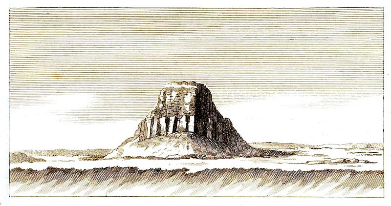
"No.
1.—View of the pyramid of Hilahoun, at the entrance to the province of
Fayoum, at the end of Bar-Jusef; it was perhaps the pyramid of Menes,
if Lake Batheu was the Moeris: a series of rocks cut steeply, perhaps
received the efforts of the Nile, if formerly, by the waterless river,
it was going to throw itself into the sea by the Maréotis. This pyramid
is built of unfired bricks; a limestone construction served as its
core."
Crossing
the rich country that I have just described, where the eye discovers
twenty villages at once, we arrived at Dindyra, where we stopped to
sleep. The pyramid of Hilahoun (plate 8-1), located at the entrance to Fayoum,
seems from there a fortress erected to command it. Could this be
Mendes' pyramid? The Bathen canal, which ends there, is not the Moeris
dug by the hands of men, as Herodotus and Diodorus believe? for the
lake of Birket-ęl-Kerun, which is the Moeris of Strabo and Ptolemy, can
only ever be regarded as the work of nature. However accustomed we are
to the gigantic works of the Egyptians, we could not convince ourselves
that they would have dug a lake like that of Geneva. Everything that
ancient historians and geographers have said about Lake Moeris is
equivocal and obscure: we obviously see that what they wrote about it
was dictated to them by these colleges of priests, always jealous of
everything that concerned their country. , and who will have cast a
mysterious veil all the more easily over this province as it was
removed from the ordinary route; and from there came this lake dug
three hundred feet deep, this pyramid raised in the middle, this famous
labyrinth, this palace of a hundred rooms, this palace for feeding
crocodiles, in short all that is most fabulous in the history of
(p.135) men, and all that remains incredible to us in that of Egypt.
But,
looking at what exists, we find that there is indeed a Canal, which is
that of Bathen, and which was still under water from the flood when we
approached it on several occasions. ; that the pyramid of Hilahoun may
be that of Mendes, which would have been built at the end of this
canal, which would be the Mceris; that Lake Birket-ęl-Kerun is only a
deposit of water which must have always existed, and whose basin will
have been given by the movement of the ground, maintained and renewed
each year from the excess of the overflow which waters the Faioum; the
waters will have become brackish at the time when the Nile will have
ceased to flow through the waterless river valley. The proofs of this
system are the local forms, the existence of the bed of a river
extended to the sea, its deposits and its encrustations, the depth of
the lake, its extension, its mass leaning to the north on a steep
chain, which runs from east to west, and drifts northwest to follow
down to the valley of the waterless river; finally the lakes of natron,
and, more than all this, the chain to the north of the pyramid which
closes the entrance to the valley, cut steeply, like almost all the
mountains which the current of the Nile still approaches today ,
offering to the eyes the appearance of a dry river and its destruction.
The
ruins found near the town of Fayoum are undoubtedly those of Arsinoé: I
have not seen them, any more than those which are at the western tip of
the lake, near the village of Kasr-Kerun (fig.2); but I was shown the plan, and
it only offers a few rooms, with a portico decorated with a few
hieroglyphs [1].
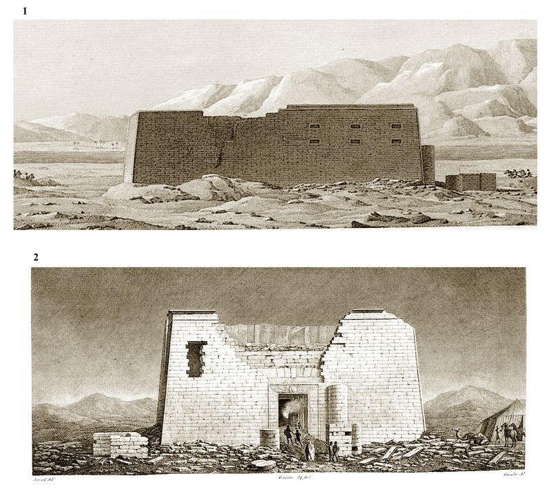
"Fig.1.
Side view of the temple called Qasr Qeroun, taken from the south side,
at sunset....Half a league from the temple, and at the foot of the
Libyan range, we see the lake called Birket el-Qeroun, the
remains of the ancient lake of Moeris".
"Fig. 2. Facade of
the temple, seen at night, and drawn from the east side. The monument
is supposed to be lit by beautiful moonlight, such as is constantly
seen in the climate of Egypt. At the entrance to the temple, we see
travelers preparing to enter the building, under the guidance of their
guides; to the right is the caravan camp. We can see, on the stones
from the demolition, a particular chevron mark ; one of these
stones bears a small Greek inscription."
The pyramid of Hilahoun, the most
dilapidated of all the pyramids I have seen, is also the one which had
been built with the least magnificence; its construction is composed of
masses of limestone, which serve as the core of a heap of uncooked
bricks: this frail construction, (p.136) perhaps older than the
pyramids of Memphis, nevertheless still exists, such is the climate of
Egypt is favorable to monuments; what would have been devoured by some
of our winters victoriously resists here the destructive weight of a
mass of centuries.
Footnotes:
1.
[Editor's note:] The Temple of Kasr Kerun was dedicated to the
crocodile god Sobek-Ra, the most widely worshipped deity in the
Fayoum region. It is a Ptolemaic temple (323 -30 BC) but has not been
dated more precisely due to the absence of inscriptions. Built of
blocks of yellow limestone, the interior is well preserved with
numerous small rooms or chapels. One contains reliefs showing Sobek
with the head of a crocodile, as well as one of the Ptolemaic pharaohs,
whose name was not preserved.
[Continue to next part]
[Return to Table of Contents]
|
v |
| Southport main page Main
index of Athena Review
Copyright © 2023 Rust Family Foundation.
(All Rights Reserved). | | |
.
|