Athena Review Image Archive ™
El Lejjun: Satellite image of Roman fortress with plan
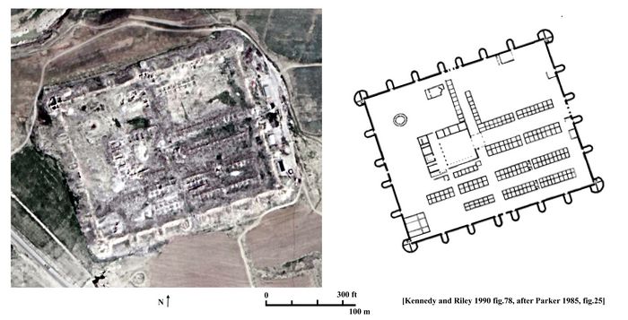
El Lejjun: satellite image of fortress with plan (Google Images; Kennedy and Riley 1990 fig.78.)
The large Roman legionary fortress at El Lejjun is located in central Jordan, 16 km northeast of Kerak. The fort's coordinates are N 31.237258, E 35.868365. Two km to the northwest is the much smaller fort at Khirbet el Fityan. Water was provided by a nearby spring, and two Roman roads went past the fort on the east.
The fortress is one of the largest in the East, covering an area of 242 x 190 meters. Its wall are 2.4 meters thick, built of cut stone fastened with mortar. There are four large oval or fan-shaped towers each 18 meters in diameter, with twenty U-shaped intermediate towers each projecting 11 meters (Kennedy and Riley 1990).
The interior contains a headquarters building (principia), seen at left in the plan, and several blocks of barrack rooms below and at right. The fortress is estimated to have housed a garrison of 1000-1500 legionary soldiers, typical of Late Imperial legions which were considerably smaller than the earlier legions.
Excavations
show that the fortress dates from about AD 300, and continued in use
until the sixth century. The fortress is identified in the Notitia Dignitatum as that of the Praefectus Legionis Quartae Martiae, Betthoro, under the command of the Dux Arabiae.
[Source: Kennedy and Riley 1990, Rome's Desert Frontier from the Air.]
Copyright © 1996-2020 Rust Family Foundation (All Rights Reserved).