Athena Review Vol. 5, no. 1
Records of Life: Fossils as Original Sources
4. Point Bars and Meandering Rivers
19th century River Historians
 Geological
strata and their fossils are mapped by paleontologists as past living
layers, composed of sediments anciently laid down by rivers,
lakes, oceans, and wind, and filled with associated organisms, and now
turned into layers of sedimentary rock with fossils. Reading the
layers as changing forms of past and present geologic environments, and
periodic deposition, is based first on the study of present changes in
rivers, lakes, and other geologic features. This branch of geology is
called geomorphology, or the "study of earth forms". It can also be
applied to ancient changes in the environment. The geomorphologists
studying ancient river courses have borrowed a few terms from 19th
century riverboat captains, such as documented by Mark Twain. While
Murchison and Sedgwick were mapping the Paleozoic strata of Wales, Mark
Twain was helping map the mid-19th century Mississippi River.
Geological
strata and their fossils are mapped by paleontologists as past living
layers, composed of sediments anciently laid down by rivers,
lakes, oceans, and wind, and filled with associated organisms, and now
turned into layers of sedimentary rock with fossils. Reading the
layers as changing forms of past and present geologic environments, and
periodic deposition, is based first on the study of present changes in
rivers, lakes, and other geologic features. This branch of geology is
called geomorphology, or the "study of earth forms". It can also be
applied to ancient changes in the environment. The geomorphologists
studying ancient river courses have borrowed a few terms from 19th
century riverboat captains, such as documented by Mark Twain. While
Murchison and Sedgwick were mapping the Paleozoic strata of Wales, Mark
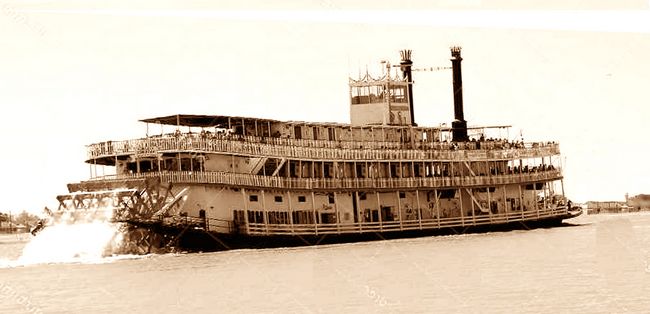
Twain was helping map the mid-19th century Mississippi River.Fig.1: Mississippi River steamboat.
 Fig.2: Portrait of the author Samuel Clemens (Mark Twain) in 1871 (Photo: Matthew Brady, Library of Congress)
Life on the Mississippi by Mark Twain was first published as a serial in Harpers Magazine in 1875. The book is a unique study of America's largest river, "The Big Muddy," as well as a classic piece of Americana, based on Twain’s experiences as a riverboat pilot just before the Civil War. It describes the lower Mississippi and its towns from the 1840s-60s in some detail. It is also full of anecdotes about “river men,” an engaging group of rascals and outrageous braggarts (such as one called “the Child of Calamity”) who knew by heart almost every reef and backwater in the 1200 miles between St. Louis and New Orleans.
Learning about the river, as Twain discovers during his apprenticeship as a “cub” pilot, is a meticulous process which takes up a good portion of the story. Every sandbar, shoal, chute, and channel in the lower Mississippi was marked (whether drawn on a map, written in a log, or stamped in the mind of the pilots) as a “point” to be steered between or avoided. The pilot had to memorize it all well enough to know the shape of the river and its depth at any given bend, nd even to be able to steer at night in pitch black darkness, to avoid running aground. Known sand or gravel bars were called “point bars” – a basic term which remains in use today in the geology of meandering rivers, past and present. River men took depth soundings with a knotted cord (one knot per fathom), frequently calling out “mark twain,” meaning two fathoms or twelve feet of water, just enough to float a paddle-wheeler. This key element in river navigation became the pseudonym of Samuel Clemens, author of Huckleberry Finn and other American classics.
The lower Mississippi below Cairo, Illinois becomes a meandering river which frequently changes its course, creating new channels by cutting across narrow spits of land. The meanders have predictable patterns, where the inner bank, due to higher energy water flow, erodes as a “cut bank” and the outer bank is built up as a point bar, as the river dumps its heavier sediments going around a curve. During floods, the lighter sediments are also deposited along levees. These topographic features remain highly visible after the river has found a new channel.
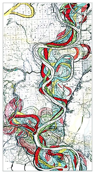
Before they are deeply covered by sediments, the point bars and levees of abandoned river channels are easy to see in aereal photos. Beginning in the 1940s, using aerial photos combined with numerous core samples, the geologist Harold Fisk mapped the Holocene courses of the Mississippi for about 10,000 years back to the last ice age (fig.3). Fisks’s initial study has been continued and refined to the present day by other geologists, with the same techniques applied to many rivers around the world. Many of the abandoned channels contain archaeological sites which were once on active rivers.
Importantly for this discussion, the point bars, levees, and other features of river channels can also be reliably mapped in cross section, going far back in geological time. Thus, if you took the entire lower Mississippi Valley mapped by Fisk and other geologists for the last 10,000-12,000 years and turned it on its side, it would represent a vertical section about 1000 miles long from north to south and 100 miles wide east to west, but often not amounting to more than a few dozen meters in depth.
Fig.3: Map of present-day and abandoned channels of the Mississippi River (Fisk 1944).
Ten million years from now, when the Mississippi valley is buried much more deeply by later deposits, Fisk's vertical section representing the Holocene would constitute a buried geological formation with layers which future geologists could read like a book. After a few million years, the buried mud and silt of the Mississippi levees will turn into shale or mudstone, while the sandy banks and shoals with their point bars will become sandstone of various grades.
The channels and banks known to Mark Twain and his riverboat mentors as point bars will then be visible in cross section as thin layers of shale and sandstone, called crossbeds by geologists, which run at angles to the prevailing beds or layers. Such crossbedding and other indicators of river currents provides essential clues to the locations of buried ancient river courses. In these strata, future paleontologists would find fossils of fish and plants contained in the shale and sandstone layers, along with the fossilized bones of various land animals (perhaps including a few careless 19th century rivermen who may have fallen from their rafts while brawling).
Extending far beneath the level of Mark Twain’s river are successively older layers, normally subject to interpretation by the common-sense principle of superposition (older layers are covered by younger layers), but inevitably, with some folding or faulting due to plate tectonic shifts in the Earth's crust (i.e., orogeny) or earthquakes. As "Strata Smith" and many others have demonstrated, typical fossils are to be found in each layer which reflect past environments and evolutionary stages. Below the glacial era of the Pleistocene (showing meandering vs braided channels, representing warm vs dry layers in the Mississippi valley) are layers from the Tertiary periods (Pliocene down to Paleocene, 2-65 million years ago), with fossils of ungulates and crocodilians and perhaps a few small Eocene primates. Below this are the Mesozoic periods (Cretaceous, Jurassic, and Triassic periods; 210-65 million years ago), the age of reptiles including dinosaurs and sub-tropical vegetation. Still further down, pehaps now a few hundred meters below the surface, begin the Paleozoic strata dating back 245-390 million years ago, when the first land animals (tetrapods) developed from fish into amphibians, reptiles, and synapsids (the ancestors of mammals), during the Permian, Pennsylvanian, Mississippian, and Devonian periods.
The continental formations of Earth are slowly, but continually, changing, as the lighter continental plates "float" on top of the heavier basement rocks of the planet. At various times in the ancient past, the globe would look quite different from today's configuration of land. For example, geological strata from the Permian period (298-252 million years ago), well exposed in Texas, Oklahoma, western Russia, and other zones of rich oil fields, represent an Earth
 where most land areas were joined in a supercontinent named
Pangaea, which included all present continents except eastern Asia,
separated by a circumscribed sea called the Tethys Sea. A northern area
called Laurasia included North America, Europe, the Urals, and the
Baltic zone; and a southern region called Gondwanaland included South
America, Africa, India, Australia, and Antarctica. The
surrounding sea is called the Panthalassa Ocean.
where most land areas were joined in a supercontinent named
Pangaea, which included all present continents except eastern Asia,
separated by a circumscribed sea called the Tethys Sea. A northern area
called Laurasia included North America, Europe, the Urals, and the
Baltic zone; and a southern region called Gondwanaland included South
America, Africa, India, Australia, and Antarctica. The
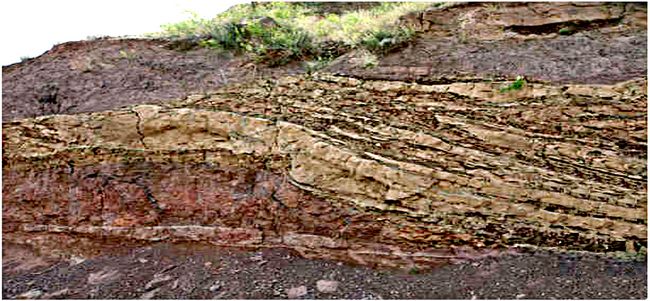
surrounding sea is called the Panthalassa Ocean. Fig.4. Point bars viewed as cross-bedding, in section from Late Permian deposits in northern China (Zhu et al. 2019).
Throughout Pangaea, vertebrates were diversifying, particularly reptiles whose amniotic (egg) reproduction allowed them more freedom of movement through the land than amphibians. A typical Permian-age strata in the Russian Urals, northern Texas, or northern China (fig.4), usually with cross-bedded shales and sandstones indicative of the point bars of ancient rivers or thin layers of lake deposits, might yield dozens of species of fish, amphibians, reptiles, and synapsids in a single fossil concentration or “bone bed.” The geomorphology of these ancient riverine environments can become readily comprehensible, if attention is paid to basic markers.
References:
Clemens, Samuel 1875. Life on the Mississippi. Harpers Magazine, Harpers, New York.
Fisk, Harold 1944. Geological Investigations of the Alluvial Valley of the Lower Mississippi River.
Zhu, Z., Liu, Y., Kuang, H. Benton, M.J., Newell, A.J., Xu, H., An, W., Ji, S.,Xu, Peng, N. & Zhai, Q. 2019. Altered fluvial patterns in North China indicate rapid climate change linked to the Permian-Triassic mass extinction. Nature
Glossary