Athena Review Vol. 5, no. 1
Records of Life: Fossils as Original Sources
3. Strata and stratigraphy
Strata.
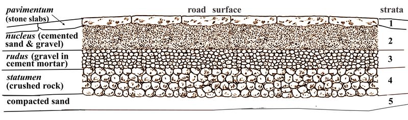
The term strata, derived from the ancient Romans, actually has two meanings; first, layers or levels, and secondly, roads. Between 50 BC - AD 400, the Romans built roads all over Europe and the Mediterranean region, whose straight courses are still followed today and built over by many modern roads. The Roman roads were constructed in successive layers of sand, loose stones, cemented gravel, concrete, and paving stones (fig.1). These gravel and pavement layers were called strata, with a single layer called a stratum (from the Latin verb sternere “to spread, scatter, or strew around” ).
In the case of roads, the word stratum (the past participle of sternere) thus meant a "spread layer" of gravel or paving stones. Paved Roman streets, roads, and other thoroughfares were called strata via; with via, the Latin preposition for “through,” used for paths, streets, and roads not init
 ially
paved. Today one of the Italian words for street is via, with strada
used for road, and autostrada for highway. Also derived from Roman
strata via are the German word strasse for street, and the Dutch word
straat, closely linked with the Old English straet (used, for
example, in the 10th century Anglo-Saxon poem Beowulf), and modern
English street.
ially
paved. Today one of the Italian words for street is via, with strada
used for road, and autostrada for highway. Also derived from Roman
strata via are the German word strasse for street, and the Dutch word
straat, closely linked with the Old English straet (used, for
example, in the 10th century Anglo-Saxon poem Beowulf), and modern
English street.Fig.1: Cross-section of ancient Roman road, showing construction layers or strata.
English and other modern languages have also incorporated the ancient Latin terms strata and stratum into generic terms to refer to any kind of layer or levels (as in “stratified society,” “upper stratum,” “stratisphere,” and similar phrases). The term strata was in this way used by 17th-19th century European engineers and surveyers to describe specific layers of rock encountered while digging mines, tunnels, or canals. Since then the study of geological layering (including the layering of fossils) has been known as stratigraphy, meaning "the mapping of layers."
Layered sedimentary rock formations were first studied as organized sequences which could be identified, found elsewhere, and compared, by the Danish anatomist Nicholas Steno (or Niels Stenson) in the 1660s. Steno first described in published form the principle of superposition, that younger rock layers and their fossil contents are higher than older ones.

This basic advance in stratigraphy is simply the recognition that rock layers represent specific intervals of a long sequence in time, are the result of active process in the land or sea, and are directly related to the fossils within them. After a survey of exposed layers of sedimentary rock layers (primarily, limestone) in cliffs and hillside roads of Italy, Steno found that the limestone layers were originally layers of suspended materials in oceans that gradually settled into horizontal layers, with new layers superimposed on older ones. Plant and animal remains were often trapped in the layers, and were the same ages as their respective layers. They had turned to stone, like the layer containing them, either as impressions in the layer's rocks, or by replacement with other rock or minerals. They were then covered over with other sediments and organisms, which eventually also turned to stone.
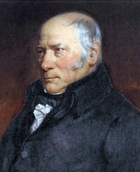
Fig.2: Portrait of Nicholas Steno (1638-1686).
This concept of sequential layering (called Steno’s Law of Superposition) is now considered the most basic principle of stratigraphy. It means that both the rock and their contents in lower layers are older than those in upper layers, unless some later processes, such as an earthquake, disturbed this arrangement. Since the original layering of these rocks was horizontal (prior to any faulting or folding of the rocks), it follows that diagonal, folded, or vertical layers have been altered either by earthquakes or by mountain building forces such as volcanos, which may have lifted certain formations higher than others.
Regarding the creation of fossils, Steno well understood that as the rocks formed, the remains of life were turned into fossils and preserved in that layer. He explained the replacement process of fossilization in terms of the then current belief that matter was composed of tiny “corpuscles” (somewhat comparable to molecules). Regardng the common ly found sharks tooth fossil, Steno proposed that the corpuscles in sharks teeth were replaced individually by mineral corpuscles. Thus while gradually turning from tissue to stone, the sharks teeth retained their original form. This is not very different from currently accepted explanations of fossilization by mineral replacement.
The recognition that fossils derived from originally living creatures had also previously been made by a few original thinkers, as outlined in the previous section. Steno, however, with his study of sedimentary rock formation, was the first to specifically explain how fossils were snapshots of life at specific times in Earth’s history, and that rock layers or strata formed slowly over time. Together these two concepts lie at the basis of today’s paleontology and geology.
Mapping the Strata.
The modern science of geology in Britain literally began with a mining engineer and canal surveyor named William Smith (1769-1839), who made the first accurate geologic maps of England and Wales. Smith began work as a
 surveyor’s apprentice around the coal mines of Devonshire in
the 1780s, then in the 1790s supervised a six-year project to dig
the Somerset Canal in southeast England.
surveyor’s apprentice around the coal mines of Devonshire in
the 1780s, then in the 1790s supervised a six-year project to dig
the Somerset Canal in southeast England.Fig.3: Portrait of William Smith (National Portrait Gallery, London, ca. 1831)
Smith, who kept accurate records of the different rock layers and their properties related to their suitability for excavation in canals (for which he was nicknamed “Strata Smith” by his associates), was also interested in the fossils found in the layers. As sections were dug through the local sedimentary rocks such as limestone, sandstone, or shale along the canal routes, Smith noticed that certain layers of rock consistently contained similar fossils, and that these varied predictably from top to bottom.
In his own words, “each stratum contained organized fossils peculiar to itself, and might, in cases otherwise doubtful, be recognized and discriminated from others like it, but in a different part of the series, by examination of them.”
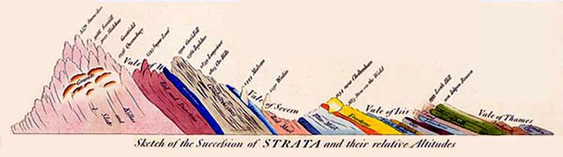
Fig.4: Sketch map of British stratigraphy from Dover to Wales (with older layers successively toward the west.
Following the same line of reasoning previously used by Steno, Smith saw that the strata thus in themselves held the key for comparisons between fossil beds, which Smith called “the principle of organic succession.” A sequence of s
 pecific fossils (representing types or species of
ancient life) were directly linked with specific types and layers of
rock, also identifiable as a sequence, which could then be defined as
an organized formation. Importantly, the same sequences of rock layers
and fossils, once accurately recorded as geological formations, can be
found in different places.
pecific fossils (representing types or species of
ancient life) were directly linked with specific types and layers of
rock, also identifiable as a sequence, which could then be defined as
an organized formation. Importantly, the same sequences of rock layers
and fossils, once accurately recorded as geological formations, can be
found in different places.Smith was the first to clearly describe local units of stratigraphy, or the correlation of layers and their contents, as organized geological formations, used in recording both the geologic history of the earth and the fossil record of related organisms and their development. This practical concept of sequential geological formations is, needless to say, essential to the relative dating of fossils, and a basic component of their paleontological descriptions.
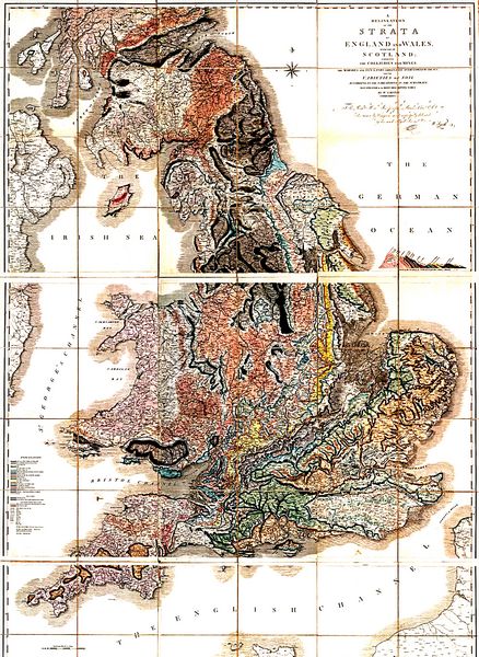
Fig.5: Geological Map of England and Wales, published by William "Strata" Smith in 1815.
From the 1790s onward, Smith created a series of geologic maps throughout the counties of England and Wales, leading to the first accurate description of geological formations throughout Great Britain. The stratigraphy was graphed in section maps, such as shown in fig.4, where the diagonal layering shows the entire stratigraphy of Britain to be faulted. The later layers are seen on the east (starting with the Late Cretaceous period at the Cliffs of Dover, from 70 mya), overlying successively earlier layers to the west, ending in Wales with the rock layers from the Cambrian period (500-540 mya).
These section drawings were translated into surface formation maps, the first geologic maps of Britian, which Smith published at his own expense in 1815 (fig.5). Smith also published, the following year, an illustrated guide to the fossils of each geological stratum described in the maps (fig.6). Since Smith had no academic credentials, however, his maps and fossil reports were at first ignored by established scientists – while the maps were freely plagiarized by publishers. Smith meanwhile went deeply into debt and was even placed in debtors prison for several years.
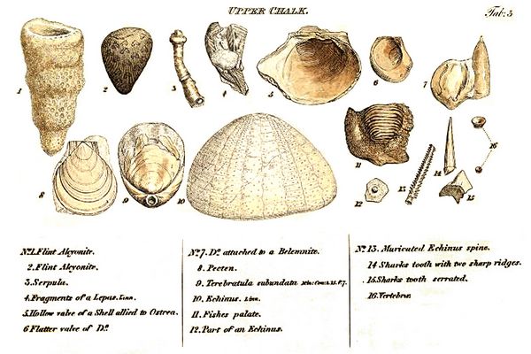
Fig.6: Marine fossils from a Late Cretaceous layer in the chalk cliffs of southern England, from Smith's 1816 publication. Among the fossils s
 In
France, at about the same time William Smith was composing his
geological maps of England, George Cuvier and Alexandre Broussart were
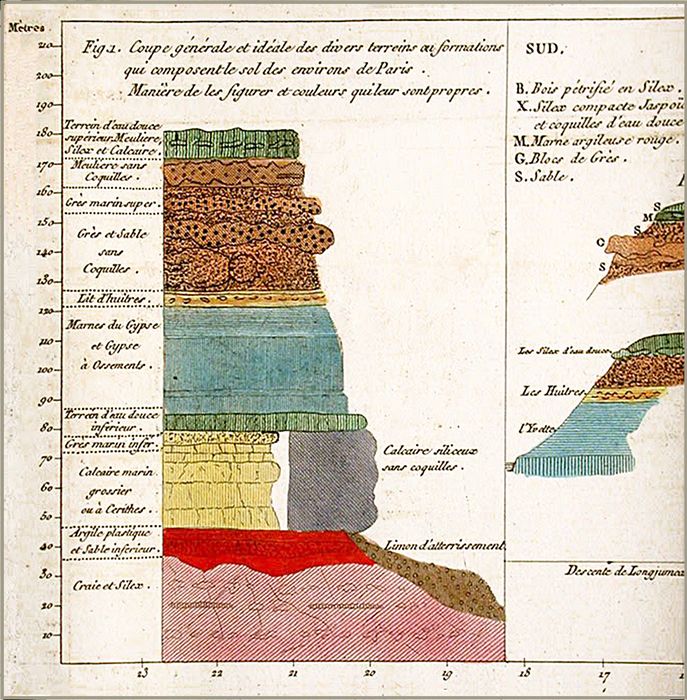
mapping the Paris Basin. In 1808, Cuvier and Broussartt published a
series of sections totalling about 300 m in depth, including various
fossil-bearing layers (fig.7).
In
France, at about the same time William Smith was composing his
geological maps of England, George Cuvier and Alexandre Broussart were
mapping the Paris Basin. In 1808, Cuvier and Broussartt published a
series of sections totalling about 300 m in depth, including various
fossil-bearing layers (fig.7).The stratigraphy of the Paris Basin includes levels from the Mesozoic era which represent shallow seas, of the same Late Cretaceous era as the Cliffs of Dover mapped by Smith. The lower stratigraphic levels are composed mainly of layers of marine limestone containing mollusks and other marine organism fossils from the Jurassic and Cretaceous periods, overlain by Tertiary sandstones "sans couqelles" (lacking shells).
Fig.7: A portion of the stratigraphic sections of geological formations in the environs of Paris, recorded by Broussart and Cuvier (1808).
Interpreting the Strata.
The president of the London Geological Sciety who presented William “Strata" Smith with his medal in 1831 was a Cambridge cleric and geology professor named Adam Sedgwick, who the same year had a young field assistant named Charles Darwin. Sedgwick eventually was able to correlate an abundance of fossils found in early geological layers in Wales and adjacent Cornwall and Devonshire to define the Cambrian era, the earliest geological period then known with fossil evidence. This was named for Cambria, the ancien
Sedgwick explored the fossil-bearing strata in Wales, England, and Scotland together with Roderick Murchison, a Scottish aristocrat who, as a young man, had fought in the Peninsular War against Napoleon. Murchison, devoting himelf to geology, was later, between 1831-1841, to define the Silurian, Devonian, and Permian periods. He spent the late 1820s with Sedgwick in France and Switzerland, studying the stratigraphy of mountain ranges. They were also joined at times by the young geologist Charles Lyell, already a fossil expert, and later famous as an author of a widely read geological textbook (1833, 1850).
Among the lasting contributions of Lyell was to introduce the “uniformitarian” theory to Charles Darwin, who as a young man read Lyell's geology textbook during his work as a naturalist in the 1833-5 voyage of the British ship Beagle The basic "uniformitarian" concept, which originated with the late 18th century naturalist James Hutton, was that slow, incremental changes over vast stretches of geological time could explain major changes in both geological formations and the fossils they contained. At that point, in the early to mid 19th century, the time scale now seen for earth of 4.5 billion years might have seemed a little surprising even to believers in uniformitarianism, but perhaps not unwelcome, as such vast time periods would provide even more time for things to gradually evolve and change. Darwin first applied Lyell's uniformitarian approach to early marine rock strata he found in Argentina, displaced high above current sea level, during the Beagle voyage. He later applied it to a deep time context established for the natural evolution of plant and animal species, in his landmark 1859 publication, On the Origin of Species.
References:
Broussart, Alexandre and George Cuvier 1808
Darwin 1839 Voyage of the Beagle
Lyell 1833 Principles of Geology
Murchison, Roderick
Sedgewick, Adam
Smith, William 1815
Smith, William 1816
Steno, Nicholas. 1667. Nicolai Stenonis Elementorum Myologiae Specimen, seu Musculi Descriptio Geometrica, cui accedunt canis carchariae dissectum caput et dissectus piscis ex canum genere. Florentiae : ex typ. sub signo Stellae, via Bibliothèque interuniversitaire de médecine, Paris.
Glossary