|
Rumen Ivanov Archaeological Institute and Museum, Bulgarian Academy of Sciences, Sofia . Abritus
is located about 50 km south of the Danube (fig.1) in the northeastern
Bulgarian town of Razgrad, on the Hissarlik plateau (from Hisar,
Turkish for “fortified hill”). The Roman military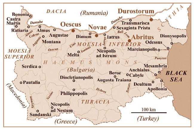 base evolved from a castellum at its 1st century AD beginnings, to a walled fortress by the early 4th century AD. This settlement continued into the early Byzantine period. base evolved from a castellum at its 1st century AD beginnings, to a walled fortress by the early 4th century AD. This settlement continued into the early Byzantine period.
Fig.1: Map of present-day Bulgaria showing Roman provinces, major towns, and military sites (after S. Goshev and R. Ivanov).
Written Sources: Abritus is frequently
mentioned by ancient Greek, Latin, Gothic, and Byzantine authors in
reference to a sanguinary battle there between the Goths and the Romans in AD 251, where the emperor Decius was killed.
A
second group of records pertains to town administration and the
bishop’s residence at Abritus during the Late Ancient era of the
5th-6th centuries AD (see Ancient Sources in bibliography).
Archaeological discovery of Abritus:
Until systematic excavations began in 1953, it was believed the
Hissarlik held the ancient town of Dausdava (Dausdaua), mentioned by
the Alexandrian Claudius Ptolemaeus in his second century AD Geographia
(III, 10, 6). The most popular choice, meanwhile, for the location of
Abritus had been the village of Aptaat, northeast of Razgrad near the
Bulgarian-Romanian boundary. In 1942 this village was even (perhaps a
bit too optimistically) renamed Abrit.
The
excavations, however, conducted in 1953-1978 by the Archaeological
Institute and Museum of Sofia under Prof. Teofil Ivanov, together with
the Town History Museum in Razgrad, found decisive evidence that
ancient Abritus lay at the modern town of Razgrad. In 1954 a
sacrificial stone altar to Hercules was found in Hissarlik from the
time of Antoninus Pius (AD 135-161) Within the inscription was the name
of the legionary settlement (canabae) at Abritus:
[Her]culi
sacrum./[P]ro salute Antonini/ Aug(usti) Pii et Veri Caes(aris).
/Veterani et c(ives) Romani/ et consistentes/ Abrito ad ca[n(abas)]/
posueru[nt].
Other
inscriptions helping to verify the site’s location include a milestone
found 1.5 km east of the Hissarlik in 1980, dating from the reign of
Emperor Phillip the Arab and his son, the Caesar Phillip (AD 245-247):
Imp(eratori) Caes(ari)/ Mar(co) Iulio/ Philippo/ pio filici (sic). Per/terr(itorium) Abri(ti) /m(ille) p(assuum) I.
(“By the Emperor’s son Caesar Marcus Julius Phillip, one mile from the territory of Abritus.”) A gravestone dated to the 4th-5th century AD contains the words civ(itas) Abr(itus),
ie., “the town Abritus.” Also noteworthy is that, at eleven different
places along the ancient town’s fortification wall (figs.3,4,7,8,11),
stone blocks are inscribed with a big letter “A,” which is undoubtedly
an abbreviation for Abritus.
Site topography:
the fortified plateau of Hissarlik slopes down from the southeast above
the river Beli Lom, a tributary of the Roussenski Lom which flows into
the 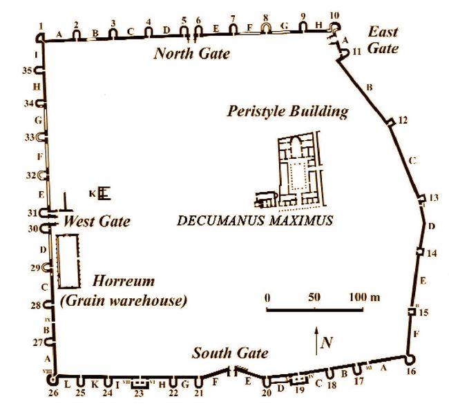 Danube at Rousse, site of the Roman fort Sexaginta Prista. Since
ancient times, this fertile alluvial region has contained agricultural
and cattle-breeding fields and vineyards providing food for both civil
and military populations. Three burial grounds or necropoli (only
partially excavated, with results still unpublished) dating from Roman
and Early Byzantine periods have been revealed near Abritus, one to the
north of the settlement, and the other two located to the south and
southwest. Danube at Rousse, site of the Roman fort Sexaginta Prista. Since
ancient times, this fertile alluvial region has contained agricultural
and cattle-breeding fields and vineyards providing food for both civil
and military populations. Three burial grounds or necropoli (only
partially excavated, with results still unpublished) dating from Roman
and Early Byzantine periods have been revealed near Abritus, one to the
north of the settlement, and the other two located to the south and
southwest.
Fig.2: Layout of the castellum at Abritus, showing outer wall towers and interior structures (after T. Ivanov 1980).
The Thracian Settlement:
In 1953, during archaeological excavations at Hissarlik hill, a
previously unknown Thracian occupation was discovered. Dating from the
4th century BC, these finds show the existence of a local settlement
long before the Romans conquered this region and, during the reign of
Claudius in AD 45, founded the province of Thracia.
Shedding
new light on the Thracian dynasty and its relation to the Roman empire
was an inscription found late in 1953 by T. Ivanov, while excavating a
Christian basilica. Here a white marble tablet reused as building
material had a Greek inscription mentioning the Thracian ruler
Rhoemetalces II (fig.3)
“During the reign of Rhoemetalces over the Thracians, the grandson of
Cotys, basileus and grandson, on his mother’s side of Rhoemetalces,
basileus, son of Reskouporis, dynast of the Thracians, Apollonios... strategos of A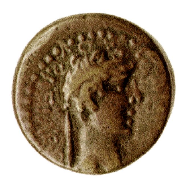 nchialos, Selletika and Rhysika had this altar erected.” nchialos, Selletika and Rhysika had this altar erected.”
When first carved, his name went with the
title “a dynast of the Thracians.” After services rendered for Tiberius
in AD 26, however, the inscription was altered to the higher title of
king (Basileus). Within a period of only 13 years this dynasty underwent radical changes in Imperial favor.
Fig.3: Coin of Thracian king Rhoemetalces II, from period of Tiberius (Athena Review). Unable
to abide this humiliation, in AD 19 Reskouporis invited his nephew and
rival Kotys III to be his guest, and then treacherously killed him.
Reskouporis was captured by the order of Tiberius (fig.4) and exiled to
Alexandria, where, the same year, he was killed in “an attempt to
escape.” Rhoemetalces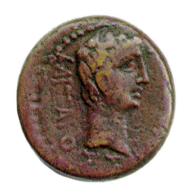 II, son of Reskouporis, succeeded to his father’s title of dynast. In AD 26, new rebellions burst out and Rhoemetalces II helped the Romans with his army. For this he was given the title basileus, “King of the Thracians,” thus recovering the status enjoyed by his grandfather. II, son of Reskouporis, succeeded to his father’s title of dynast. In AD 26, new rebellions burst out and Rhoemetalces II helped the Romans with his army. For this he was given the title basileus, “King of the Thracians,” thus recovering the status enjoyed by his grandfather.
Fig.4: The Roman Emperor Tiberius (AD 14-37) on the obverse of the coin in fig.5 (SGI-5404; Athena Review).
Roman legions in Abritus:
At the end of the 1st century until AD 136, the legionary unit cohors
II Lucensium settled in Abritus. Known at the site from a gravestone
inscription, this cohort was formed in Spain. An inscription from
Montana in northwest Bulgaria shows they were in Moesia by AD 78. After
cohors II Lucensium left Abritus, it was replaced by another (still
unidentified) military unit. Unfortunately, no remains of a related
military camp have so far been discovered. Excavations in the central
and the western part of the archaeological site have been limi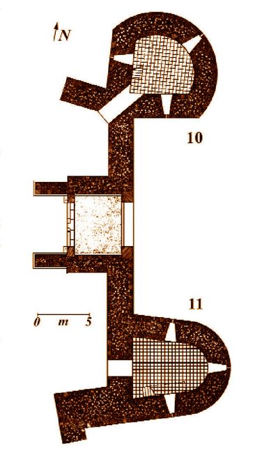 ted by
the presence of a modern factory. ted by
the presence of a modern factory.
Canabae and Castellum:
The makeup of the military settlement at Abritus has been much debated.
An inscription from the late 3rd century containing “Abrito ad c...”
was read by Prof. T. Ivanov as ...Abrito ad c[an(abas)], referring to the canabae or town attached to the military base. An alternate reading by Prof. F. Vittinghoff, however, is ...Abrito ad c[as(tellum)], based on a parallel from CIL III 942 of ...natus in M[oe]si[a] infer(iore) castell(o) Abritan(orum), referring to the castellum. Fig.5: Plan of the East Gate (J. Furkov; in T. Ivanov and S. Stoyanov 1985).  During
this late 3rd century period in Abritus, it is known that there were
two main settlement areas, the castellani dwelling in the castle or
walled fort and the cives who lived in the civilian town. T. Ivanov’s
reading (supported by B. Gerof) is that canabae existed not only in the
more familiar structure of castra-canabae-vicus (ie., as at Novae and
Oescus), but also near a castellum, as part of a
castellum-canabae-cives formation. In another epigraphic fragment on a
monument from the late 2nd century the fixing of the boundaries of
prata publica (the public pasture) is recorded. During
this late 3rd century period in Abritus, it is known that there were
two main settlement areas, the castellani dwelling in the castle or
walled fort and the cives who lived in the civilian town. T. Ivanov’s
reading (supported by B. Gerof) is that canabae existed not only in the
more familiar structure of castra-canabae-vicus (ie., as at Novae and
Oescus), but also near a castellum, as part of a
castellum-canabae-cives formation. In another epigraphic fragment on a
monument from the late 2nd century the fixing of the boundaries of
prata publica (the public pasture) is recorded.
Fig.6: A reconstruction of the East Gate at Abritus (J. Furkov; in T. Ivanov and S. Stoyanov 1985). Third century Gothic invasions:
The greatest Barbarian invasion into the provinces of Lower Moesia and
Thracia during the period of the Principate was that of the Got hs in
the middle of the 3rd century. At the end of AD 248 and in early 249,
they, in conjunction with other tribes, attacked the town of
Marcianopolis (present Devnya). On the heels of this came a second big
invasion in the spring of AD 250, when the Goths crossed the Danube in
four important sections between Augustae (present village of Harlets)
and Sexaginta Prista (Rousse). The largest contingent of Goths, under
the command of their leader Kniva, besieged Novae and the castra
legionis I Italicae (pp.37-44). From there they started for the town of
Nicopolis ad Istrum. hs in
the middle of the 3rd century. At the end of AD 248 and in early 249,
they, in conjunction with other tribes, attacked the town of
Marcianopolis (present Devnya). On the heels of this came a second big
invasion in the spring of AD 250, when the Goths crossed the Danube in
four important sections between Augustae (present village of Harlets)
and Sexaginta Prista (Rousse). The largest contingent of Goths, under
the command of their leader Kniva, besieged Novae and the castra
legionis I Italicae (pp.37-44). From there they started for the town of
Nicopolis ad Istrum.
Fig.7: Reconstructed North gate, viewed from the inner side (J. Furkov; in T. Ivanov a nd S. Stoyanov 1985). nd S. Stoyanov 1985). The Roman Emperor
Trajan Decius (AD 249-251) met the Goths near the town of Augusta Traiana
(present Stara Zagora) where he was defeated. Soon after that the
Gothic forces captured Philippopolis, the largest and wealthiest town
in Thracia. The third Gothic wave came with the northward withdrawal of
the Barbarians, aimed at crossing the Danube. By this time Decius had
managed to restaff his army with new soldiers.
Fig.8: The northern fortification wall at Abritus (after T. Ivanov and S. Stoyanov 1985). 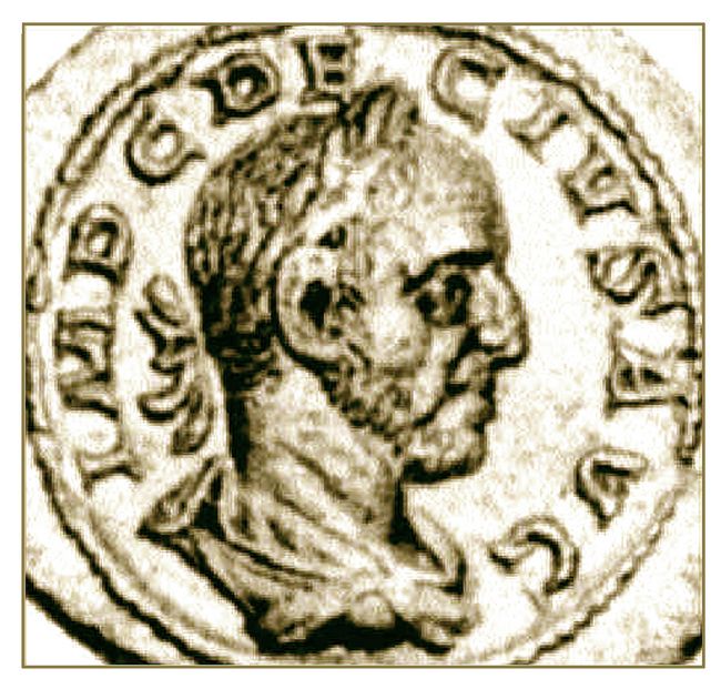 Trajan
Decius had been born in the village of Budalia, near the town of
Sirmium in present-day Serbia. The first Roman citizen from Illyricum
to became an emperor, he also had served, under the name of C. Messius
Quintus Decius Valerianus, as governor of Lower Moesia in AD 234, and
later as governor of the province of Hispania Citerior in AD 238. Decius and his wife Herennia Etruscilla are portrayed on
Roman coins (figs. 9,10). Trajan
Decius had been born in the village of Budalia, near the town of
Sirmium in present-day Serbia. The first Roman citizen from Illyricum
to became an emperor, he also had served, under the name of C. Messius
Quintus Decius Valerianus, as governor of Lower Moesia in AD 234, and
later as governor of the province of Hispania Citerior in AD 238. Decius and his wife Herennia Etruscilla are portrayed on
Roman coins (figs. 9,10).
Fig.9: Trajan Decius silver coin (Sear 2693;CNG 1997). 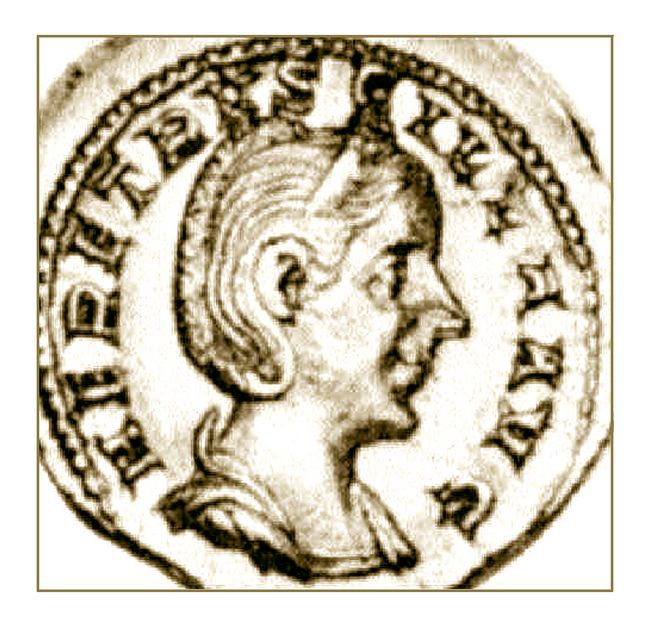 In AD 251
the famous battle with the Goths at Abritus brought near-catastrophic
defeat for the Romans. The Emperor Decius was fatally wounded and,
according to 4th century accounts by Eutropius and Aurelius Victor, sank on his white horse into a swamp. The next day, soldiers sought in vain for his body armor. In AD 251
the famous battle with the Goths at Abritus brought near-catastrophic
defeat for the Romans. The Emperor Decius was fatally wounded and,
according to 4th century accounts by Eutropius and Aurelius Victor, sank on his white horse into a swamp. The next day, soldiers sought in vain for his body armor.
Fig.10: Silver coin of Herennia Etruscilla, wife of Trajan Decius (Sear 2732; CNG 1997). As reported by the late Roman writer Cassiodorus in his Chronicles: the Emperor’s son Herennius also died in the battle: Decius cum filio suo in Abritto Thraciae loco a Gothis occiditur.
("The Goths killed Decius and his son in the Thracian settlement of Abritus.") Later a treaty, humiliating in its terms for
the Empire, was signed.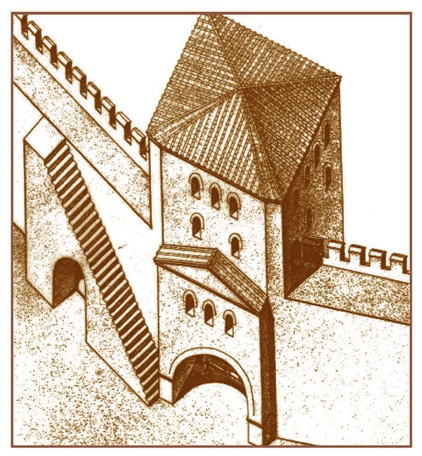
Abritus During the Late Empire:
After the Gothic invasions, the walls and fortications of Abritus were
significantly strengthened. Systematic archaeological excavations since
1953 have revealed the complete Late Imperial fortification system of
Abritus (fig.2). During the reign of Constantine the Great (AD
306-337), a vast fortified area or castellum of about 16 ha (40 acres)
was surrounded by walls totalling 1,400 m in length, including four
gates and thirty-five towers. The latter are primarily U-shaped,
although several are quadrangular or fan-shaped (figs.5-8,11). Fig.11: Reconstruction of the South gate at Abritus (J. Furkov; in T. Ivanov and S. Stoyanov 1985). 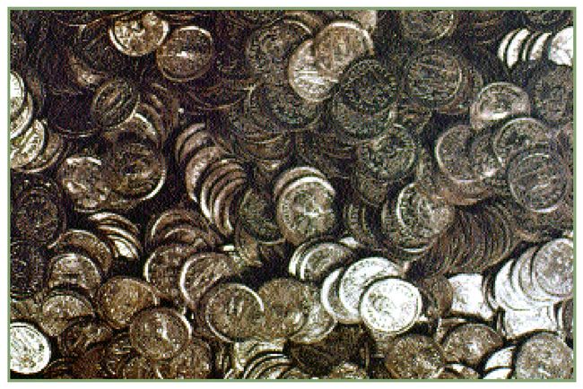 In
1971 a cache of 835 gold coins weighing about 4 kg was discovered along
the inner wall between towers 12 and 13. These coins (fig.12), the
largest cache found so far in the town and its environs, date from
between AD 408 and 488. They were minted in Constantinopole (Istanbul),
Thessalonika in northern Greece, and Antioch in Syria. In
1971 a cache of 835 gold coins weighing about 4 kg was discovered along
the inner wall between towers 12 and 13. These coins (fig.12), the
largest cache found so far in the town and its environs, date from
between AD 408 and 488. They were minted in Constantinopole (Istanbul),
Thessalonika in northern Greece, and Antioch in Syria.
Fig.12: A cache of 5th c. AD gold coins found by Towers 12 and 13 in Abritus (T. Ivanov and S. Stoyanov 1985).
 Two early 3rd century officials at Abritus: Inscriptions from Abritus give information on two officials called beneficiarii consularis.
Their functions relate to the control of the station on the road from
Odessus through Marcianopolis and Abritus to Sexaginta Prista. Two early 3rd century officials at Abritus: Inscriptions from Abritus give information on two officials called beneficiarii consularis.
Their functions relate to the control of the station on the road from
Odessus through Marcianopolis and Abritus to Sexaginta Prista.
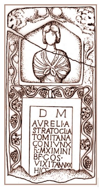
The first example (fig.13) is on the gravestone of a woman who died
around the time of Caracalla (AD 211-217).
D(is)
M(anibus) / Aurelia / Stratoclia / Tomitana / coninx / F(lavii)
M(aximi) / b(ene)f(iciarli) co(n)s(ularis), / vixit ann(is) XX / Hic
S(ita) e(st).
(“To
the underground gods Aurelia Stratoclia from Tomi (Constanca on the
Black Sea in Rumania), wife of Flavius Maximinus, beneficiarius
consularis, lived twenty years. Here is she laid.”)
Fig.13: Grave Marker of Aurelia Stratoclia from Tomi (R. Ivanov 1994).
A
second inscription, dedicated to the Celtic horse goddess Epona, dates
to the consulships of Lateus and Cerialis (AD 215):
...Eponae / Reg(inae). Pro sal(ute) D(omini) / Nostri) M(arci)
Aur(elii) Antonini [Pii] / fel(icis) Aug(usti). Val(erius) Ruf(us,
inus, inianus) / b(ene)f(iciarius) co(n)s(ularis) leg(ionis) / XI
Cl(audiae) Anto / ninianae V... / Laeto II et Ceria[le cos.]
(“To
Epona Regina. For the health of our master Marcus Aurelius Antoninus
Pius Felix Augustus. Valerius Rufus (or Rufinus, Rufinianus)
beneficiarius consularis of the 11th Claudian legion...under consuls
Laetus and Cerialis.”) Grain warehouse: Approximately
9.5 m south of the western gate was excavated a grain warehouse or
horreum with thirteen counterforts along both its east and west walls
(fig.14). The rectangular ground plan ofthe building is orientated
from north to south, with outer dimensions of 56.25 m by 20.2 m. The
warehouse was in use between the 4th and 6th centuries AD. To the n orth
of the western gate, another building has been partially uncovered. It
also has a quadrangular plan, with dimensions of 34 by 17 m. On the
shorter, southern wall was an entrance which was very near to the gate.
It is presumed that this structure was a barracks, built after the
erection of the fortification wall. orth
of the western gate, another building has been partially uncovered. It
also has a quadrangular plan, with dimensions of 34 by 17 m. On the
shorter, southern wall was an entrance which was very near to the gate.
It is presumed that this structure was a barracks, built after the
erection of the fortification wall.
Fig.14: The horreum or grain warehouse, reconstructed (J. Furkov; in T. Ivanov and S. Stoyanov 1985).
Also
discovered in Abritus were several buildings showing different stages
of construction. Excavations were carried out east of the center of the
fortified settlement, in a section which included two quarters. Four
houses were found here, each with a rectangular plan. One room in the
basal level of building no. 3 produced two coins of Emperor
Constantius (AD 337-361). Two fragments remained of a Latin inscription
built into the outer wall. This mentioned the name of Romulianus,
commander of a Dalmatian army unit [p(rae)p(ositus) equ(itum) Dalm(atarum) Beroensium commita(tensium)].  This
movable unit, whose name was unknown until recently, was stationed in
Abritus for a brief period of time. Later, on the remains of the first
two buildings was erected a third structure. This
movable unit, whose name was unknown until recently, was stationed in
Abritus for a brief period of time. Later, on the remains of the first
two buildings was erected a third structure.
Fig.15: The courtyard of the peristyle building at Abritus (T. Ivanov and S. Stoyanov 1985). All
five of the houses recently excavated (nos. I-V) had been destroyed as
a result of the Gothic invasions in AD 376-378. Here, not  more than a
few years before the end of the 4th century AD, was erected a large
building with a peristyle courtyard (figs.15,16) which revealed two
stages of construction. Initially, in a structure designated
Peristyle building VI, the southern part was built, consisting of
six shops with a central entrance in the middle and a colonnade in the
Ionic style in front of them. Later, the rest of the building was
constructed (called Peristyle building VII; fig.16). more than a
few years before the end of the 4th century AD, was erected a large
building with a peristyle courtyard (figs.15,16) which revealed two
stages of construction. Initially, in a structure designated
Peristyle building VI, the southern part was built, consisting of
six shops with a central entrance in the middle and a colonnade in the
Ionic style in front of them. Later, the rest of the building was
constructed (called Peristyle building VII; fig.16). Fig.16: A view of the peristyle building no.VII at Abritus (after T. Ivanov and S. Stoyanov 1985).
 Dating
from the middle of this later phase was a rectangular yard surrounded
by a colonnade in the Roman-Ionic style, with columns 3.5 m high. Two stores or shops were situated to the east and west of the building
(fig.17). Within, nine rooms were situated on both sides of the central
rectangular hall (tablinum), a large official room entered through a
door on the southern wall containing a courtyard (fig.18). Dating
from the middle of this later phase was a rectangular yard surrounded
by a colonnade in the Roman-Ionic style, with columns 3.5 m high. Two stores or shops were situated to the east and west of the building
(fig.17). Within, nine rooms were situated on both sides of the central
rectangular hall (tablinum), a large official room entered through a
door on the southern wall containing a courtyard (fig.18).
Fig.17: Colonnade in front of the shops (after T. Ivanov and S. Stoyanov 1985). To the east
of the Peristyle building VII, along the north-south cardo, the remains
of two more quadrangular houses of the same period were discovered.
 Fig.18 (right) Reconstructed courtyard at Abritus (J. Furkov; in T. Ivanov and S. Stoyanov 1985). In
1887 an early archaeologist and schoolteacher, A. Yavashov, found
remains of an old Christian basilica situated 50 m northeast of the
western gate. In 1953 T. Ivanov carried out new excavations in this
building. The basilica, dating to the middle of the 6th century AD, is
orientated east-west. Measuring 18 m in length by 13.5 m in width, it
contains three naves, a three-section narthex and a semicircular apse
before the central nave (fig.19).

Fig.19 (left): Plan of the basilica from the middle of the 6th century (after T. Ivanov and S. Stoyanov 1985) The Bulgarian Settlement: Abritus
was destroyed at the end of the 6th century by invading Avars and
Slavs. About two centuries later, in the eastern part of the Hissarlik
district, there arose a Medieval Bulgarian settlement. The new
occupants constructed simple earthen dwellings inside the larger shells
of the Roman and Late Ancient buildings. Excavations have revealed many
ovens and a number of whole and fragmented pottery vessels, as well as
metal tools dating from the Medieval period. The settlement existed
until the end of thc 10th century, but was ultimately destroyed when
large areas within present-day Bulgaria fell under the control of the
Byzantine Empire.
.
.
Bibliography:
. Ancient sources on Abritus:
On the Battle with the Goths, AD 251: The most contemporary account is
by Athenian historian P. Herennius Dexippos, who writes in his 3rd c.
AD Historical Chronicles that
the emperor and his son found their death near Abritus in the so-called
Forum Tebronii. (Decius actually died in the Forum Sempronii). The
battle is later described by 4th century historians Eutropius (AD 365)
and Aurelius Victor, and the 5th century statesman Cassiodorus (AD
487-583) in his Chronica (chap. 252). Subsequently, the 6th century Byzantine historian Jordanes, in his summary of the Goths called Getica
(103), says that “Decius was surrounded by the Goths near Abritus a
town in Moesia and perished there. This place was still called
‘Decius’s altar,’ because before the battle he offered up unusual
sacrifices” (...ad Abrito Moesiae civitatem..., qui locus hodiemque
Decii ara dicitur).
On Abritus as a town: Late ancient sources include the Synecdemus
of Hieroclis (AD 527-8), mentioning Abritus among 7 towns of the
province Moesia Secunda. Procopius of Caesarea, writing ca. AD 551 in
De aerdificiis (IV, 11) notes many towns in the Lower Danube, and
reports that the Emperor Justinian I (AD 527-565) reconstructed the
town of Abritus. chap. 252).
.
Recent sources:
Clarke, G. 1980. “Dating the Death of the Emperor Decius.” in ZPE 37, 114-116. Bonn.
Georgiev, P., G. Chobanova, I. Rahneva, and D. Dimitrov. 1991. Abritus. Razgrad.
Gerov,
B. 1961. “Zur Identität des Imperator Decius mit dem Statthalter C.
Messius Q. Valerianus.” in Band 39, 222-226. Klio, Berlin.
Gerov,
B. 1963. “Die Gotische Invasion in Mösien und Thrakien unter Decius im
Lichte der Hortfunde.” in Acta antiqua Philippopolitana, 128-146.
Serdicae.
Gerov, B. 1970. “Zum Problem dr Strategien in roemischen Thrakien.” Klio, Berlin, No.52.
Ivanov,
R. 1994. “Zwei Inschriften der beneficiarii consularis aus dem Kastell
Abritus in Moesia Inferior.” in ZPE 100, 484-486. Bonn.
Ivanov, T. 1963. “Archaeologische Forschungen in Abritus (1953-1961).” AAph, Studia archaeologica, Serdicae.
Ivanov, T. 1980. Abritus: A Roman Fort and Early Byzantine Town in Moesia Inferior. Sofia.
Ivanov, T., and S. Stoyanov. 1985. Abritus. Razgrad.
Marinova,
L., and M. Lazarov. 1962. “A New Inscription of the Strategos
Apollonios Eptaikentos.” in Bulletin dell’Institut d’Archeologie, XX,
197-203. Sofia.
Tacheva, M. 1995. “The Northern Border of the Thracia Province to the Severi.” in Thracia, Vol.11, 427-434. Serdicae (Sofia).
Velkov,
V. 1989. “Cohors II Lucensium in Moesia and Thrace.” in Acta
Archaeologica Academiae Scientarum Hungarica Vol. 41, 251, Nr. 13.
Budapest.
Velkov. V. 1991. “Inscriptions de Cabyle.” in Cabyle Vol. II, 15 (n.36). Sofia.
Vittinghoff,
F. 1968. “Die Badeutung der Legionslager für die Entstehung der
römischen Städte an der Donau und in Daiken.” Studien zur europäischen
Vor-und Frühgeschichte, 136 (n.34). Neumünster.
Vittinghoff, F.
1971. “Die rechtliche Stellung der canabae legionis und die
Herkuftsangabe castris.” Band 1, 307. Hiron, München.
This article appears in Vol.2, No.3 of Athena
Review.
.
|